So every year I take a camping trip with my son Elliott and most years I try to make it genealogy-related. In 2016 I couldn't because my wife was pregnant and too far along for me to venture far, but the other 3/4 of our trips have been great ways to do some hands-on, in-person research in places far from home while also trying to connect with my heritage and have my son connect with his.
This year, our trip was to Kentucky. The vast majority of my Kentucky ties are to my father's side of the family. There are some loose connections to my mother's side--her Binkley and Shackelford branches settled in Kentucky at various points, though they were Tennessee natives--but most of my trip was dedicated to the families of my father's grandmothers, Elnora Pauline Clements and Leola Marie Barnett.
The first half of the trip focused on the family of my great grandma Pauline, while the second half was dedicated to my great grandma Marie.

This is me in November, 1988, meeting my great grandma Pauline Clements Martin for the first time in Del City, Oklahoma.

This is me in November, 1988 meeting my great grandma Marie Barnett Marks for the first time in Ardmore, Oklahoma.
Day 1 - Friday
Our first stop on our trip would be Louisville, Kentucky. I did not find a lot of camping grounds really close to Louisville, and I wanted to make some stops around Dayton (some toy shops, since Elliott and I have taken to checking out vintage toys wherever we can), so we ended up camping at a VFW Campground in Franklin, OH on Friday night. Larry Stamper from the Franklin VFW kindly allowed us to stay there while he was there with his family and friends. Coincidentally, it turns out Larry's Stamper and his Combs ancestors were from the same region of Kentucky we would be visiting later--Breathitt and Perry Counties. He was even married to an Eversole for a brief time, so I thought twist of fate was pretty interesting. Chances are somewhere down the line Larry is our cousin; all the eastern Kentucky families out that way are connected one way or another and more than one of my aunts and cousins married into the Combs family.
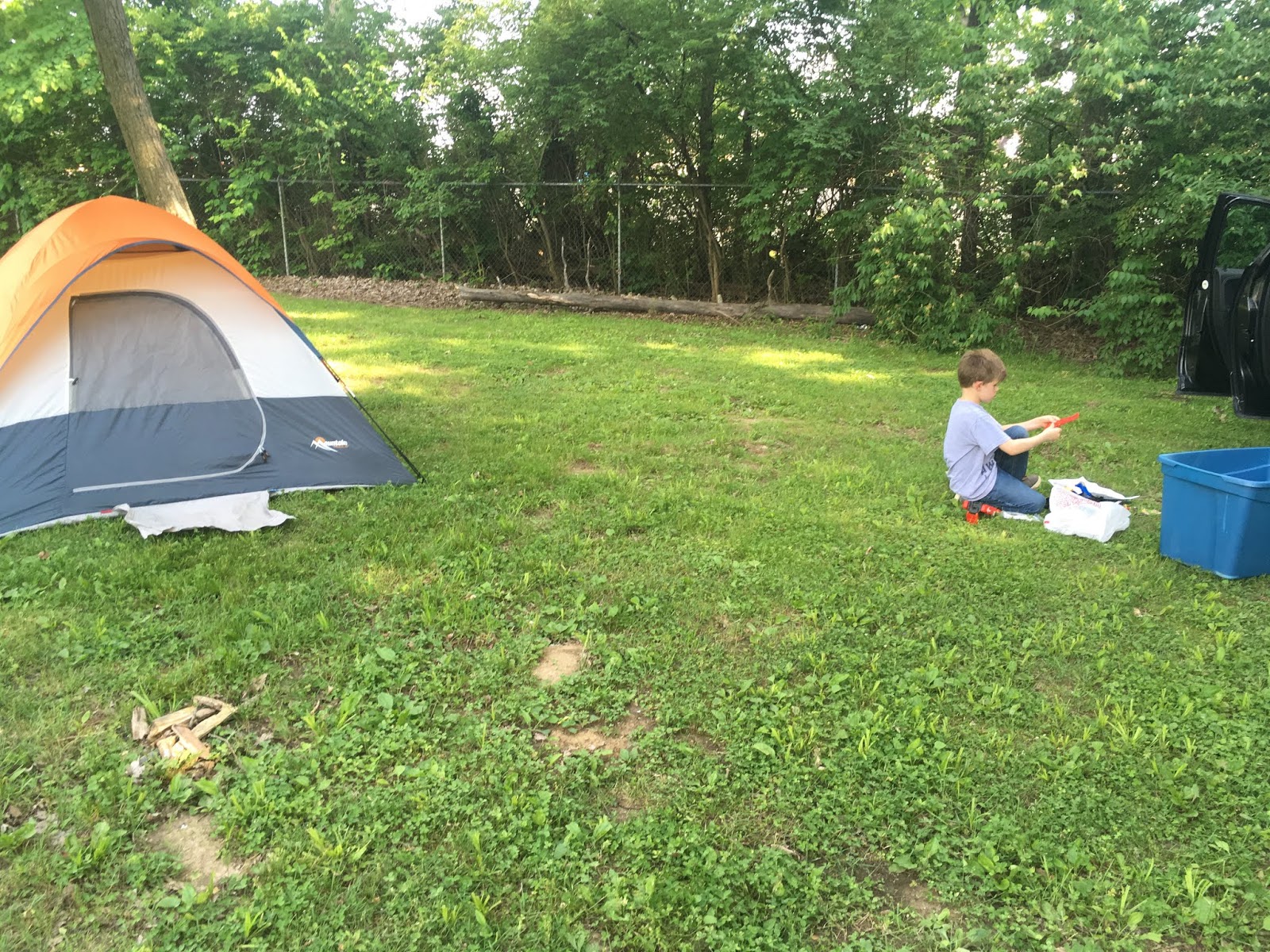
Elliott enjoying some of his new toys at the campsite.

Elliott and his new buddy Kylen.

Pavilion at the VFW Campground.
Day 2 - Saturday
After a good night's rest, we drove two hours to the Louisville Zoo, where we visited the first of many cool family landmarks. Apparently, the land on which the zoo now resides was originally the property of my 6th great grandfather, Jenkin Phillips. He is an ancestor of my paternal grandmother and came from Loudoun County, Virginia--where he rubbed elbows with my ancestors John Marks and Abraham Lewis, who are ancestors of my paternal grandfather and maternal grandfather, respectively. Funny how I can find all three men in the same county together in the 1700s, and then 200 years later their descendants married in Oklahoma.
Anyway, sometime after the end of the American Revolution (by 1784 at the latest), Jenkin re-settled in what is today Jefferson County, Kentucky, and his plantation is now the Louisville Zoo. When the zoo was constructed, the owners kindly left the family plot more or less intact. There is one small unmarked headstone in the stone-fenced lot, and a military marker for Jenkin has been placed in there as well. Jenkin served under Washington during the Revolution. A larger concrete marker has since been erected and includes the names of many family members who are presumed to be buried there as well.
We headed for the cemetery plot first thing, but encountered some animals we had to stop and see along the way.

Excited for a day at the zoo! Geese EVERYWHERE!

Warthog!

Rhino!

Giraffe!
And at last--but really not very far from the main entrance--we reached the memorial site for our Phillips ancestors.

Elliott with the modern memorial with list of purported burials in the family cemetery.

Military marker for Jenkin Phillips.

View from the back of the cemetery.

Entry gate to the cemetery.

Phillips Cemetery Memorial Marker

View of cemetery in full


One small unmarked fieldstone remains.
Jenkin was my 6th great grandfather; we descend from his daughter, Susanna Phillips Riley. He was a patriot and the progenitor of hundreds of descendants living today, and I was pleased and proud to have gotten to visit this site and share it with Elliott.
Soon we were back to enjoying the animals. The Louisville Zoo was very clean and had a wide variety of exhibits. We got to see just about everything Elliott wanted to see except the Arctic penguins, which were not available on the day we came through.

Lion!

Another giraffe!

Goats!

Gorilla!

Snow leopard!

Wallaby!

Bald eagle!

Sea lion show!
After stops at a couple of stores in Louisville, we headed for Vastwood Park in Hawesville to camp for the night. The campgrounds were really nice, and we found a cool spot near the water and had a great time.


Day 3 - Sunday
In the morning, we drove to Owensboro. After crossing the Hancock County line a few miles west of Yelvington, Kentucky, a town our ancestors frequented before it almost completely burned to the ground in the 1890s, we stopped at this historical marker. Today, the area where this marker lies is called Maceo. The marker is a commemoration to Josiah Henson, a man who escaped slavery by leaving for Canada and later became a minister and met the Queen of England. Born in Maryland, he was owned by my uncle Isaac Riley, who in a deal to avoid his slaves being seized over debt sent Henson and his other slaves to his brother, my ancestor Amos Riley.


The area where this marker lies is in the vicinity of where the Amos Riley plantation was. However, it is believed by the man that owns this land that his actual plantation was further northeast of this spot, closer to the Blackford Creek. This is indicated by the frequent mentions of the creek by Henson in his autobiography. Plat maps of this area a couple of decades after Amos Riley's passing showing his descendants in possession of land further northeast of this area also seems to indicate that this marker may be off by a few miles, but it may also have been placed here in a spot close enough to a major road so as to be relatively easily accessible.
This is not a part of our family history that I am particularly proud of, but it is one I am not going to gloss over or ignore. I explained to Elliott that his ancestors were not perfect people and sometimes did evil things like taking 'ownership' of others and forcing them to do labor for them for next to nothing. He needs to recognize the faults of his forebears in the hopes that he will strive to be better than them. I also explained that doing evil things did not make that person inherently evil. I told him that he does not come from evil people, but flawed ones. Slave owners could be otherwise honorable, charitable, kind people both during and after the institution of slavery. I cannot speak as to whether or not Amos Riley was an otherwise good person; Henson does not paint him as any more cruel than any other person that "owned" other people in this time. But the point was to recognize the sins of our forefathers and maintain a balance between gratitude for the role they played in our existence while simultaneously renouncing some of the choices they made in life. I believe one can do both, and I hope that is something Elliott will come to terms with as he grows up.
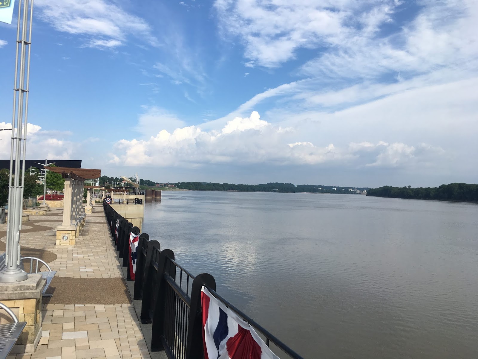
We had some time to kill in the morning, so we went to Smothers Park in Owensboro, where Elliott got to enjoy a really nice park and I got to enjoy some time relaxing next to the scenic Ohio River, which creates the border between Kentucky and Indiana.


We then took a walk around downtown Owensboro to see what we could find.

Information about burned courthouses during the Civil War is certainly relevant to someone like me with a lot of early Kentucky ancestral ties.


Owensboro has a really clean and peaceful downtown; it seems like it would be a nice place to live.

Next, we ventured to the Rosehill-Elmwood Cemetery in Owensboro to find the grave of our uncle, Camden Riley, son of the aforementioned Amos Riley. He was a prominent attorney here for decades, and early in life an active politician. According to his obituary, at age 22 he was elected for a single term to the Kentucky State House of Representatives. Having been born in 1816, that would be approximately 1838. His obituary also reports that at age 32, he was elected to the Kentucky State Senate, so in roughly 1848, and again for a single term. It should be noted that according to the History of Kentucky, Volume 2 by Lewis Collins (1878), Camden was elected to the House for Daviess County in 1845 and he state Senate in 1850, so at ages 29 and 34, respectively. He did not marry his wife until 1854, so if she was the primary reporter for his obituary, she may have mistaken the years he served and his age at those times. His obituary further reports that he attended undergraduate studies at Augusta College in Bracken County, studied law under a Judge Field of Louisville, and received his law degree from a law school in Lexington.
This cemetery is really the combination of two cemeteries, Rosehill and Elmwood, located across the street from another but managed by the same entity. The Rosehill-Elmwood office sent me a map of the Elmwood Cemetery, the older of the two, and told me they had him buried in Section C, but no specific information as far as plot number; I would simply have to search the entire section for him.

Map of Elmwood Cemetery in Owensboro, Kentucky
Fortunately, having seen a photograph of his stone on Find A Grave, I knew what to look for. Even more fortunately, as soon as I parked on the road between sections C and D and looked out my window, I could see the name "Riley" not 40 yards in front of me. I didn't even have to get out of my car to find it!

The Riley plot in middle just a few steps from my car.

Headstone of Camden and Ellen Kendall Riley.

Elliott with the stone of his uncle, Camden Riley.

One of two stones in front of Camden's, Susan Kendall was both the sister of Camden's wife Ellen and the wife of Camden's brother, William Riley. Sometimes referred to as "William Amos Riley", the only source for that name is the death certificate of William's daughter. Her death occurred in the 1950s and the source was her child, who never knew their grandfather, so I take that middle name with a grain of salt.

This nearly-illegible stone is for James Kendall. Despite the vast majority of this section of the cemetery being documented on Find A Grave, I was surprised to find this stone missing. It turns out James, a brother of Ellen and Susan, was murdered by a sheriff's deputy who later became Owensboro Chief of Police. James, apparently while drinking, reportedly sent a letter to the deputy's wife which the man took offense to. He confronted James and shot him; James died hours later. The deputy was later acquitted on a defense of succumbing to "temporary insanity". You've got to love the nonsense defenses they came up with in those days. Today in the same state, that same crime would likely earn the perpetrator a death sentence; he certainly would never have become Chief of Police.
Per the Daviess County Public Library website [https://www.dcplibrary.org/news/2024]: "Legion Park, the oldest city park in Owensboro (with the exception of Smothers Park which was set aside as public grounds in the 1816 plat of Rossboro), was acquired as a shady picnic area in 1894. At the time, the location of Legion Park was outside the city limits and patrons paid a fare of 5 cents to ride a streetcar the 1 and a half miles to and from the park, which was operated by the Owensboro Railway Company and ran every 20 minutes. James Hardin Hickman (1852-1931), “tall, handsome, ram-rod straight” and Mayor of Owensboro at the time, purchased the land from Camden Riley, Sr. for a total of $4,000."
The park was originally called Hickman Park and consisted of 23.74 acres deeded from Camden Riley to the city of Owensboro and its mayor, James H. Hickman. Several years later, in 1908, another of my uncles, Amos Riley Taylor (son of Camden's sister Elton), would present a speech at Hickman Park for a reunion of ex-Confederate soldiers. He grew up southwest of Owensboro in a town called Sorgho and was Daviess County Attorney for a time before heading west to St. Louis, where he became one of the most prominent attorneys of that region.

From the Messenger-Inquirer (Owensboro, Kentucky), 23 Jun 1908, Page 5. Courtesy of Newspapers.com.
So of course, Elliott and I needed to visit the park on land one uncle was owned, and where another uncle gave a grand speech. It is a very nice little park (Owensboro clearly cares about the quality of their parks and playgrounds) and we had a good time until rain forced us back to our car.


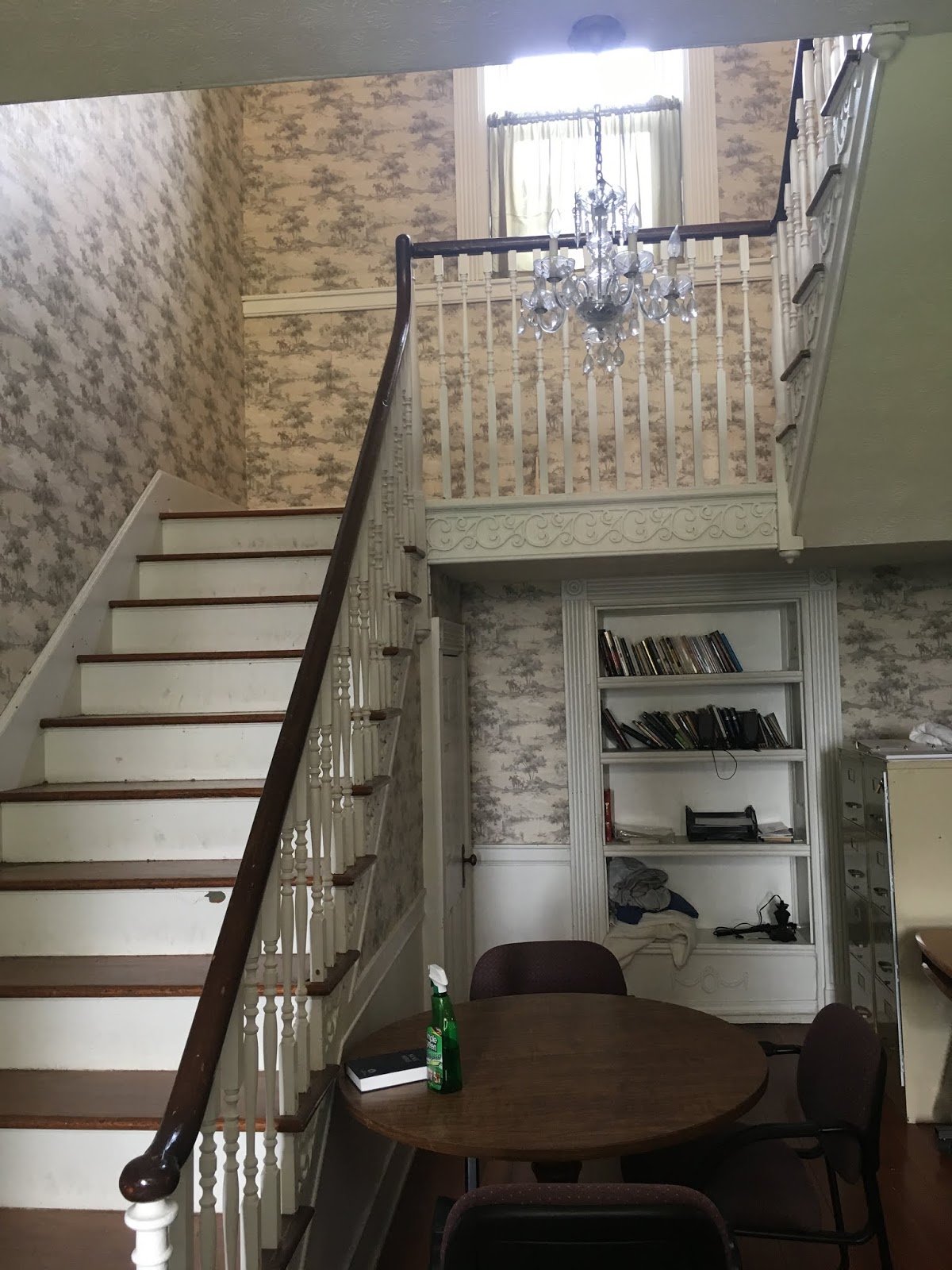
After lunch at a nice little burger joint called Wonder Whip, we weren't able to visit the library because even though it was Sunday, it was closed for Memorial Day, so we got ice cream at Dairy Queen instead while waiting for our appointment at the pinnacle of this particular day of our trip: visiting the Camden Riley house. References in newspapers as being under construction in the late 1870s and listed as Camden's residence city directories from the early 1880s til his death, this nearly-150 year old house has stood the test of time and is still in excellent condition. We were graciously allowed to tour the house thanks to both the owner, Robert Glyer, and the current occupant, Sylvia Martin; property manager Hope Margolot also assisted facilitating this visit, and I am grateful to all three for allowing it to come together.

Camden Riley House at 112 E. Fourth St. Owensboro, Kentucky

Main stairway


Original ceiling medallions.

More ceiling medallions.

Elliott was excited about the basement!

Creepy crawlspace with old junk in the basement.

Top of the staircase.

More ceiling medallions upstairs.
I avoided taking pictures of Sylvia's possessions as much as possible to respect her privacy. The whole house is indescribably cool and has been very well cared-for. Unfortunately, I came about ten years too late, or else I might have been the one to discover the treasure trove of pictures and documents in the attic: https://www.liveauctioneers.com/news/top-news/antiquities-and-cultures/plantation-papers-to-go-on-display-in-owensboro/

The whole collection was found in the attic of this very house just a few years ago.
THAT would have been an incredible discovery, but regardless, this house itself is a treasure and it was an incredible experience to be walking and standing in a home my uncle resided in more than one hundred years ago. My family being largely from Oklahoma, Texas, and Arkansas in the last hundred years or so, few of my ancestral homes are still standing, save the Wolf House at Norfork, Arkansas. So while people largely from this region of the country or older parts along the east coast, New England, and parts of the midwest may frequently have access to or be able to see home their ancestors lived in a century or more ago, for my particular family this is a rare treat.
We then headed back to Maceo to the area near the Josiah Henson marker. A few months ago, I made contact with George Hawes, the man on whose land that marker sits. It was believed by historians that his land made up part of the Riley plantation; as I stated earlier, that may or may not be the case. It is true that some Rileys lived on George's property in the 1900s; they apparently had a summer cabin or summer home that was not their full-time residence that sat a few hundred yards from George's house. But George had to tear it down after his cattle kept getting into the house and falling through the floors into the basement, so unfortunately I could not take any pictures of it.
The big thing I wanted to visit at George's property is an old cemetery. Another Riley cousin told me the cemetery was there, but no one seems to know the names on the stones. There are only a few headstones, and they were all moved aside for cattle to more easily graze the area where it sat several years ago by the owners previous to George. George has not paid the stones much mind or looked into who is buried there, but told me I was welcome to check it out. He drove us to the area where I was just a few feet from his cattle, but the area around the stones were still pretty grown up.

Just a few stones in the grass.

Screenshot of my location in relation to Highway 60.

Zoomed in location showing how close to the pond shown above.

This largest stone had been knocked over.

A combination of factors prevented me from exploring further. One, the stones were face down and pretty heavy to move by myself. Even if I felt I could/should move them, my paranoia in regards to copperheads--which like to live under rocks like these--had me wary about what I might find beneath them. I read up plenty about snakes in this area, and this is a prominent region for them and the time of year when they are most commonly found. I only saw one snake on this trip (a non-venomous one) but I am hyper-aware of my surroundings in case I might happen upon a poisonous one. The third factor was that it started raining and was soon storming quite hard.
Before we headed east, George wanted to take us to a small nearby cemetery just over the Blackford Creek and into Hancock County in case it could be Riley relatives. He is pretty confident that the Rileys lived closer to the creek than where his property lies, and if his land was originally part of the Riley plantation, then it was a small part and not the main/central part of the farm.
I believe somewhere there is a Riley Family Cemetery where the Rileys and many of their descendants are buried--and probably some of their slaves as well. I think if it could be found, its historical ties to Henson could lead to grants to restore it, but it has to be found first. I don't think just Amos and Susanna Phillips Riley are there, but a number of their children and grandchildren who died in Daviess County from the 1840s to 1880s and whose graves have never been found. This was not a poor family; the Rileys had plenty of money and therefore almost certainly have or had marked graves. They were not poor farmers whose graves might have been marked with a fieldstone; probate records bear out that the descendants of Amos Riley had land and funds, so the idea that they would be buried in unmarked graves seems ludicrous to me.
Could the cemetery on George's land be their's? Possibly, but from what I could see of the stones, they looked more recent than the mid-19th century--I would say early 20th century at the oldest, though I could be wrong. It's more likely there is another cemetery with a couple of miles of George's land where the family lies anonymously. Perhaps the current landowners are aware of it and ignore it, or perhaps they have never come upon it. It is also possible that like the little cemetery on George's land, the cemetery was there at some point, but was cleared/razed for crops or a grazing field. I plan to study Riley land deeds as much as I can to narrow down what land made up Amos's original plantation, and then I may start a letter-writing campaign to the current owners to see what they might know about cemeteries--present or past--that may lie on their land.
The people I think could be buried there would include but not be limited to:
[Note: I have amended this list since initially making this post as I have found where some of the people originally on the list are actually buried or found more likely places for them to have ended up.]
Amos Riley (d. before 1840)
Susanna Phillips Riley (d. after 1840)
Martha Riley Hathaway (d. 1861)
John Hathway (d. before 1870)
William Riley Hathway (d. before 1870)
John C. Hathway (d. 1881)
Cynthia Riley (d. 1846)
Infant of Camden Riley (referenced in Camden's biographical information while he was still living, I assume this child died between 1864-1860, but could have been later. Child could also potentially be buried in maternal grandparents' family cemetery, the Enoch Kendall Cemetery near Yelvington)
William Riley (d. before 1870)
And almost certainly more! There are so many people in this family that died over a forty year period (late 1840s to early 1880s) who don't have located marked graves and nearly all of whom died in or near Daviess County. Given that this family had enough money to own as much land and as many slaves as they did, there is no way they are ALL in essentially unmarked pauper's graves somewhere. Their cemetery is either hiding in the trees somewhere on or near the original Riley plantation, or was bulldozed for farm land or destroyed by flooding at some point. Either way, my hope is to someday either find it or find evidence of it somewhere.
We the drove in the pouring rain back east (and back into the Eastern Standard Timezone, as we figured out the night before we had drifted into the Central Standard Timezone without realizing we would) to Shepherdsville. There, we went to the home of our cousin Sue Clements Ray, who had invited us to stay several months ago when I was still in the process of planning out this trip and she was helping me make contact with people I needed to reach to discuss getting to see some certain landmarks on our trip.
Sue is actually our double-cousin, as her parents were cousins to one another in the Clements family. Elliott and I descend (through my aforementioned great grandma Pauline) from Dr. William Hamilton Clements, son of George Clements and Ann Hamilton. Sue descends from two of William's brothers: Leonard Franklin Clements and George Richard Clements. She was very hospitable, providing us a spaghetti dinner, along with her son and two grandchildren, and even washing some of the soiled laundry we'd accumulated on the trip.
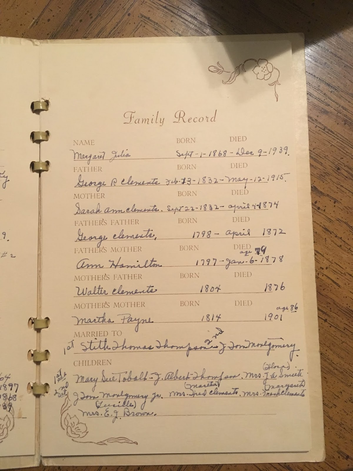
After getting Elliott to bed, I was excited to sift through genealogy materials with Sue, and boy, does she have a treasure trove! She had several original documents for various land transactions involving my 4th great grandfather, George Clements, and other relatives, as well as a number of great picture. The MOST amazing thing she had--the Clements family bible! It belonged to either George or Ann themselves (or both) and was passed down through the family. By deciphering and analyzing the handwriting for the death record entries in the bible, we were able to come up with a sequence of ownership for the bible.
It appears this bible is the original source for most of the birth and death dates for the children of George and Ann Hamilton Clements. Sister Emma Louise Donnelly, who wrote the "Imprints" Hamilton book, likely either viewed this bible herself or a copy of the entries, as the dates mirror what she published in her largely-authoritative book on the Hamiltons. I say "largely" and not "absolutely" because there were A LOT of mistakes in Sister Donnelly's book. The biggest mistake, to me personally, is the incorrect assertion that my ancestor, William Hamilton Clements, died without issue. But hey, what do I know, I just...exist, right? Clearly that was an error on her part, perhaps because the bible does not record either of William's marriages. That may have led her to believe her never married or had children, but if she had done just a LITTLE homework, she would have realized that was a faulty assumption.
I cannot speak to why George and Ann did not record William's marriages in the bible. An estrangement? Disapproval of his brides? I have no idea. But he married in first in Nelson County--adjacent to Washington County--to a notable Catholic family, so I can't see why they would have disapproved. He then moved to Missouri with his brother Leonard Franklin Clements, so clearly at least by that time he was not estranged from the whole family. He later removes to Owensboro, Kentucky (where he remarries to Mary Alice Taylor, granddaughter of Amos Riley, after he was widowed), then Kansas, possibly back to Kentucky, and then eventually to Collin County, Texas. There, in 1880, his niece Emma Parrott, daughter of Eliza Clements Parrott, is enumerated in his household, so again, he clearly was not estranged from all his family even if perhaps he was from some of them. And he may not have been estranged from any of them at all! I don't know. I do know his other siblings' marriages were recorded in the bible and his were not, so I don't have an explanation for it beyond his parents perhaps not approving of his marital choices.
But labeling William as child-less was not Sister Donnelly's only error. Numerous errors with names and birthdates--particularly for descendants of the George and Ann Hamilton Clements family--have been found, with Sue herself having a now-heavily redacted and penciled-in version of the book due to the large number of errors. That's not to say the book is not still an excellent resource--it is, especially for the early Hamilton genealogy. But the information on later generations has been found to be spotty at best.
I also wanted to share the conclusions that Sue and I reached about how ownership of the bible was passed down from the original owners to Sue. The bible starts in what is apparently Ann's hand. This is indicated by the start of the first entry which states, "I was married January the 15th, 1818" and then the entry is crossed out. She begins again writing "George Clements was married to Ann Hamilton in the year January 15th 1818". On the following page, she records first George's and then her dates of birth, but then again crosses them out and rewrites them with altered phrasing. The reason I am sure it is Ann and not George recording these entries is because on the 4th page, George's death is recorded in the same handwriting. After that, the next entry is Ann's death, and is in both a new handwriting and a new ink color, indicating that after Ann died, ownership of the bible was passed to an heir.
It would appear that heir was Mary Clements Mudd. I'm not sure why Mary would have ended up with it; she was neither the eldest child, nor the eldest daughter. But the next bible entries were for members of the Mudd family and were written in a purplish ink. It appears she made several entries for her family all at once, and then years later added further entries. Her mother died in 1878 and when she inherited the bible, she made birth, marriage, and death entries for herself and children up to that point, including her son Arthur's death being noted write after she entered her mother's death. Apparently a few years later, the same handwriting added several entries, including deaths for three of George and Anne's children: William H. (1883), Eliza Ann (1893), and Thomas E. (1899).
After that a new handwriting appears, documenting the death of Mary Clements Mudd in 1910. The same handwriting then documented Leonard F.'s (1910) and George R.'s (1915) deaths. This indicates to me that the writer of these entries--and therefore the third owner of the bible--was Robert Walter Clements. Interesting again that it did not pass to one of the older children, but actually the youngest surviving child of that family at the time of Mary's death. The last two deaths documented--written in pencil and in a new handwriting--is Robert's in 1917, and "his wife Eliza" in 1920. Robert was the last surviving child of George and Ann Clements, so who did the bible pass to next?
Robert's death entry filled the deaths section of the bible, so a blank page after that was used to record two additional deaths. I believe these were the deaths of the next two owners. After Robert, it appears the bible's owner was Annie Clements Vize, the eldest child of Robert and Eliza Clements. Her 1942 death is the top entry on the blank page and left only one final entry, for presumably the final owner: Sister Bernadette Clements. She was the next-eldest daughter of Robert and was born Katherine "Kate" Clements before taking her vows. She died 10 Mar 1947. It is unclear then if the bible passed to someone else before making its way to Sue's mother. Both Sue's maternal grandmother and her paternal grandfather were first cousins of Sister Bernadette. She still had two living siblings, so it is no clear how or why the bible transitioned out of Robert's line, but clearly it did since Sue's mother ended up with it before Sue did.
In summary, we can pretty conclusively determine that the bible passed hands accordingly:
Ann Hamilton Clements
Mary Clements Mudd
Robert Walter Clements
Annie Clements Vize
Sister Bernadette Clements
???
Martha Montgomery Clements, daughter of Margaret Julia Clements
Sue Clements Ray
It is also possible there were additional owners mixed in who simply made no entries into the records portion of the bible, but these are our best guesses as to how the bible changed hands since belonging to Ann.
This is the part where in the past I would share pictures of the pages of the Ann Hamilton Clements bible. Alas, as I have stated in some of my more recent blog posts, I have learned my lesson about what I share photos of on my blog. Due to the unfortunate habit of numerous armchair-genealogists to blindly copy everything they find on the internet attributed to their families and throwing them up on Ancestry.com and personal family websites WITHOUT citing the original OR contributing sources has brought me to the point where when I find REALLY cool stuff...I keep it to myself. And I issue a formal invitation, as is my current practice, to anyone that reads this post and would like to see the pictures I've taken of the bible, to contact me directly with their request and I will gladly help out. But like last year when I discovered a picture of my 4th great grandparents on my Conner line, I'm not going to put it out there just to see it appear on Ancestry in a few weeks and not mention that the bible belongs to Sue or that the pictures were lifted from my blog. I'm sorry, but I'm not sorry about that. Thank the thankless, entitled people out there for the inconvenience of not being able to see these amazing genealogy resources, but rest assured that if you contact me directly, I will be happy to oblige.
I will at least share the title pages to show the age of the bible, but I won't be adding the Family Records pages.


Additionally, I will share some of the other cool things Sue shared with me which--while not the original family bible--are still exciting in and of themselves.

Original document showing the purchase of the Clements family plot at the St. Rose Cemetery.

Personal record page from the funeral book of Margaret Julia Clements Montgomery.
Family record page from the funeral book of Margaret Julia Clements Montgomery.

Original deed to George Clements involving Hundley heirs.

Original deed part 2

Photograph of Robert Lee and Regina Simms Clements family

Another original deed involving Hundley heirs.

Yet another original deed involving Hundley heirs.
She had several other original deeds as well but none we really genealogically relevant, just interesting and exciting to be holding these records my ancestor George Clements once held. It's amazing these have all survived and remained in the family for so long. I also copied various family genealogy records and copied mentions of the Clements and Hamilton families and a couple of interesting letters. The other cool document I copied in addition to the George/Anne Clements bible was information from their son Leonard Franklin's bible as well. But these were not originals, but photocopies. Sue believes her nephew has the original, which had belonged to one of Sue's sisters and was also passed down through the family. This record contained birth, marriage, and death information for Leonard's family. As the copies did not include the bible's title page and year of publication, I asked if she could track down the bible and get copies of those pages for me so as to validate the information reported in the bible.
The saddest information I copied from Sue came from her brother's funeral book. Joseph Gerald Clements died 26 Apr 1946 at the age of 2 years, 7 months, 12 days. He had mistaken a glass with kerosene in it for a glass of water and died of poisoning as a result. His funeral book includes the only picture ever taken of him, a post-mortem photograph with his twin sister, Geraldine.


Around 11, we headed to bed as we had a long day before us with lots to visit.
Day 4 - Monday
We awoke early the next day to get ready for 8:30 mass at St. Rose. While I am not Catholic, my wife and children are, and I thought it would be an awesome experience for Elliott to attend mass and take communion in the same church where his 5th great grandparents did over 100 years before he was born, as well as several generations of cousins in the years since.
It was about 45 minutes from Shepherdsville to St. Rose, and as I came upon the old church, I was filled with a rush of excitement and awe at how beautiful the place is. Once I got his attention, Elliott, too, seemed as excited about it as an 8-year old with only mild interest in what we're doing could be.

St. Rose Catholic Church in Springfield, Kentucky

St. Rose Catholic Church in Springfield, Kentucky

View of the cemetery as we approach the church.

View of the church from the parking lot.

This separate part of the cemetery is reserved for all the parish priests and brothers that have served here and are buried here.


View from the top of the hill by the church back to the road and cemetery.


Elliott in the church of his 5th great grandparents.

We went through mass and Elliott--who took his first communion just a couple of months ago--got to take communion here and knowing that his ancestors and family also did so in this same room over a century ago was a pretty amazing thing. I think they would be very pleased with this Catholic boy--especially considering most of their progeny from William's line between he and themselves were Protestant. They can thank my wife for that.


The church was erected in 1852! I am confident that George and Ann Hamilton Clements, as well as their siblings in the area, were all among the first people to congregate in this building. They were almost certainly members of the church in its previous building as well. Ann died in 1878, so it has been just over 140 years since our direct ancestors walked here. (That is assuming their son William, my 3rd great grandfather, did not visit here between then and his death in 1883.)

The stained glass throughout the building is absolutely incredible.


View of the pulpit from the balcony.


I took some pictures of the oldest stones I could find--even though they aren't my relatives as far as I know--just to show how long this place has been here based on dates of death. Growing up in Oklahoma and the south in general, it is very rare to come across marked graves of this age. In fact, these are probably the oldest graves I have visited in person given that most of my cemetery-visiting has been conducted in states that weren't even states when these headstones were set.

Headstone of Henry Palmer dated 1833.

Headstone of Dr. Robert Mudd. When I first saw it, I thought the year was 1814, but turned out to be 1844, but still cool and very old!


I would have liked to have explored the cemetery further at this time to find my family, but our schedule dictated that we needed to make another stop before we did that.
Rev. Terry McIvoy is a Kentucky Baptist Missionary who runs The Way Home Ministries in Springfield. It is a halfway house for males as they transition from incarceration back into the community. The house happens to be...my 4th great grandparents' home that they built and lived in until their deaths. It remained in the Clements family (it was Sue's childhood home and passed to her brother) until the early 2000s after the death of Sue's brother. You can read more about The Way Home and its ministry on their website, where you'll also see a picture of the home: https://thewayhomesite.com/
Rev. McIvoy was kind enough to permit us to visit the house at a time when most of the residents were at work so we would be a minimal disruption. Ever since I found out about the existence of this house several years ago I have wanted to visit it. This would be the first time I visited a home built by and lived in by a direct grandparent that is more than 100 years old (not counting the homes of Jacob Wolf and Camden Riley as they are my uncles).
The house is only a few miles from the church, so the plan was to go to the house, then back to the cemetery, and after lunch we would visit a few more familial homes. The Clements house was built by the aforementioned George and Ann Hamilton Clements and is located at 5250 Bardstown Rd. It sold in 2014, so some realty websites still had some info on it; both closed listings I found incorrectly dated the house back to the 1790s (https://www.zillow.com/homedetails/5250-Bardstown-Rd-Springfield-KY-40069/105969718_zpid/). The National Register of Historic Places more properly dates it to the 1826-1850 timeframe: https://npgallery.nps.gov/NRHP/GetAsset/NRHP/88003401_text
The NRHP report also gives some interesting information reported by Fred Clements, Sue's father. He iterates a family story that soldiers were fed at the home prior to the Battle of Perryville which is pretty awesome even if it can't exactly be proven.
In general, I limited the number of pictures I took and am further limiting the photos I'm sharing because most spaces were taken up with things belonging to the halfway house and its residents and I'd like to respect their privacy as much as possible.

Back of the house from the driveway.

Living room.

Sue in the living room; the fireplace is blocked by a couch. Sue and most of her siblings were born in this room, which was her parents' bedroom when she lived here.

Front doors from within the entryway.
Main staircase.

Elliott on the staircase of his 5th great grandparents' home.

View from the front porch.

View from edge of yard.

Elliott on the front porch.

Front porch.

Elliott and I at the Clements House.

Elliott heading down to the cellar.

Elliott in the cellar.

Elliott found a little turtle.

A VERY little turtle.

Elliott wanted to take him home...

But we set him free outside instead so he wouldn't be stuck down there.
The home wasn't in the condition it was when Sue was a child, which she was disappointed about, but overall it is still in fine shape and it was incredible to walk the halls where my ancestors lived. It was a truly indescribable experience, and I'm so glad Elliott got to enjoy it as well.
On our way back to St. Rose, we stopped at the campus of the now-closed St. Catharine College, which is just over halfway between the Clements house and the church. It was a small Roman Catholic college from the early 1800s to 2016, when it closed due to financial difficulties. While I don't know specifically which of my relatives attended school there, I am confident a number of them did as my family were Catholics residing in its immediate vicinity and were generally well-to-do enough to have afforded an education there.
Still open next to St. Catharine College is the Motherhouse of the Dominican Sisters of Peace. A large number of nuns still reside there, and a few of my cousins who were nuns are buried there.


After returning to St. Rose, we set about looking around the cemetery for various Clements and Hamilton relatives. We found the majority of them; there were a few aunts and uncles I was hoping to find marked graves for to correspond with their entries on Find A Grave.com, but I was unsuccessful in locating any of them. It is noteworthy, however, that Sue has collected a good deal of evidence that a number of the oldest stones of the cemetery have mysteriously disappeared and were likely destroyed. The remains of numerous old stones can be found in the pond behind the cemetery, quite likely placed there by someone mowing the lawn and damaging or moving stones and not feeling like putting them or back or repairing them, but that is a post for another time.

Road into cemetery.

St. Rose Cemetery

My uncle George Richard Clements, son of George and Ann; his wife Martha is actually buried in Louisville. Sue and I think his headstone was probably moved to this section as it is in a much newer part of the cemetery, predating the next-oldest stone in its vicinity by over 50 years. We aren't sure how or why it ended up here, but neither of us believe this is where it started, and it's probable that his remains are not here, but rather wherever his stone was originally placed.

View from cemetery to church.

Sons of Fred Clements (Sue's brother) that died young, including the aforementioned Gerald.

Fred and Martha Clements, Sue's parents.

My uncle Robert Walter Clements, son of George and Ann.

St. Rose Cemetery

Large obelisk memorial for my uncle Alexander Hamilton, brother of my ancestress Ann Hamilton Clements. It includes the names and dates of his four spouses, but none of those four wives are buried with him; they all pre-deceased him by 40 years or more and are buried in the oldest part of the cemetery closest to the church. Alexander's memorial is in the middle of the cemetery among others that mostly died between 1860-1910. I eventually located all of their original stones except for Theresa, whose stone I know is there but I failed to locate and photograph. Alexander's home at Parker's Landing is set to be one of our destinations later in the day.

Alexander Hamilton monument.

Alexander Hamilton monument.

Stone for my uncle, Leonard Franklin Clements, son of George and Ann.

Stone of Ellen Montgomery Clements, wife of L. F.

Stone of Mary Ellen Clements, wife of L. F.

And finally, the big one: the stone of George and Ann Hamilton Clements, my 4th great grandparents.

George Clements

Ann Hamilton Cements

Stone of Nannie, the third wife of L. F. Clements.

Stone of Sarah Ann "Sallie" Clements, wife of George R. Clements

Wish I knew whose stone in the Clements plot right in front of George and Ann is missing; it is possible it is where George R.'s stone originally was, or it could be any number of other relatives whose stones are unaccounted for. The youngest children of George and Ann that died young would have been buried in the oldest part of the cemetery nearest the church, but none of their stones have been located.

First stone I found in the old section near the church was that of Harriet, one of the wives of my uncle Alexander Hamilton.

Stone of my uncle Thomas Hodgkin Hamilton, brother of Ann Hamilton Clements.

Stone of Lucinda, wife of Alexander Hamilton.

Stone of my uncle Walter Hamilton, brother of Ann Hamilton Clements.

Old section of St. Rose Cemetery.

Stone of Elizabeth, wife of Alexander Hamilton.

St. Rose Church

Elliott on the blank stretch of hill between the the church/old section of the cemetery and the newer parts of the cemetery; it is here where a number of stones are believed to have gone missing.

Historical marker for the St. Rose Priory.
We spent a good couple hours traipsing all around the cemetery and I really enjoyed myself. It is a beautiful historic cemetery and I'm glad to have family here. I told my wife if she ever wanted me to become a Catholic her she'll just need to move us here; I wouldn't be able to help myself but to get immersed in all the history and heritage here.
Among the stones I hoped to find but was not able to was the stone for my aunt Elizabeth "Eliza" Ann Clements Parrott, a daughter of George and Ann Clements. When I was unsuccessful finding her there or record of her being buried there at the library, I began to think that despite a Find A Grave memorial saying she was buried there...she probably wasn't. After I got home, I did some more digging. Her last known residence was Neosho County, Kansas in the 1885 Kansas State Census; she died in 1893. Her son George was buried at St. Francis Cemetery in Neosho County, as was my aunt (her niece) Susan Ursula Anne Clements Coomes, daughter of her brother (my ancestor) William Hamilton Clements.
I could not find but one mention of Eliza in Neosho County newspapers in the 1880s and 1890s in the collections on Newspapers.com. The Find A Grave records for St. Francis Cemetery in St. Paul, Kansas is woefully incomplete, so on a whim I contacted the secretary at St. Paul Church and lo and behold--they had her record of burial there! Matching date of death and everything. So I finally had the answer as to her final resting place! That was exciting for me. It took more work than it should have to get her Find A Grave memorial switched to the correct cemetery and state of death, but documentation and the assertion that I will gladly involve Find A Grave management should my valid and documented corrections continue to be declined eventually won over the memorial creators. And at last, one of my little genealogical mysteries was put to rest.
After lunch, we visited what is today called the Wheatley House, as it has been in that family for generations, but up until his death in 1917, it was the home of my uncle, Robert Walter Clements. Located at 4832 Bardstown Road, when coming from St. Rose, you actually come to this house before reaching the home of Robert's parents, but due to scheduling, we had to visit the houses a little out of order. This house is the only one of the four we visited this day that is not on the National Historical Places register.
What's really cool is that we have a picture taken sometime between 1910-1915 of Robert sitting in front of this very house with his wife, Eliza Hite, and two grandchildren. Ever since I found out this photo existed and the house still stood, I've wanted to have Elliott stand in the same place for a picture. And now, finally, we were able to!

Robert W. Clements on right in chair; his wife Eliza Hite Clements sitting in the other chair. They are in front of their home which is today called the Wheatley House. Photo courtesy of Dorothy Mae Wheatley Osborne.

Elliott standing in roughly the same place as his uncle Robert W. Clements sat over 100 years ago. Due to the placement of trees and shrubs it was difficult to recreate the precise angle, but I worked with what I had.

The Wheatley House, formerly the home of Robert Walter Clements.
Mrs. Wheatley was home and we spoke to her for a few minutes, but with her being mostly relegated to her chair, we did not want to bother her and we did not tour the home. But it was still amazing to get to visit the place, and we excitedly made our way to our next stop.
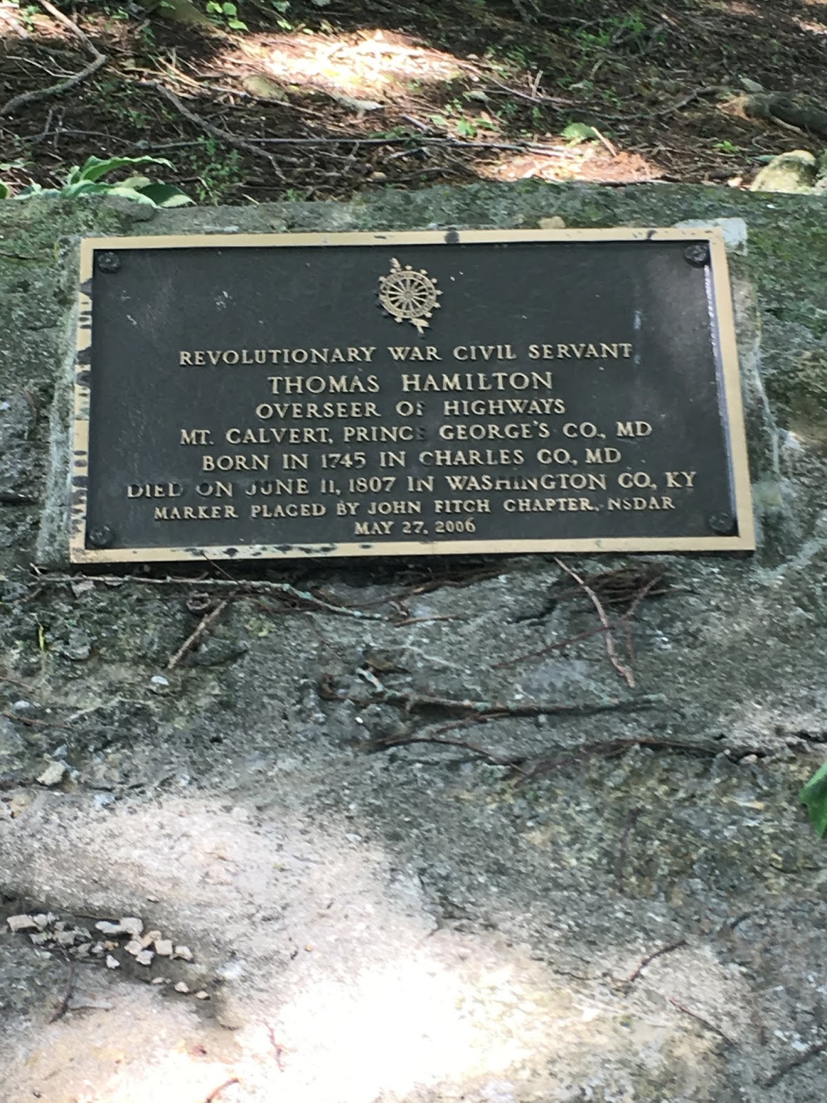
This area being Sue's childhood stomping grounds, she knows a lot of the people around as well as a lot of the landmarks. One of the lesser-known landmarks in the area is the grave of my ancestor, Thomas Hamilton. He is not buried in a cemetery, but in a solo plot behind a residence along Barsdtown Rd. about 1/4 a mile from the Clements House. It lies on private property, but with Sue's connections we were able to secure permission to visit this particular back yard and see the grave plot. A few years ago, the local D.A.R. chapter placed a marker on the concrete slab acknowledging Thomas Hamilton's civil service during the American Revolution.
Thomas was the father of my aforementioned ancestress, Ann Hamilton Clements, as well, as Alexander, Walter, and Thomas, whose grave photos I have already shared. He fathered 10 known children with his wife, Ann Hodgkin, and died in 1807, prior to the establishment of St. Rose, which is why he is not interred there.

Grave of Thomas Hamilton (1745-1807), my 5th great grandfather.

Elliott Marks at the grave of his 6th great grandfather, Thomas Hamilton.

The family story is that the grave of Thomas's wife Ann Hodgkin Hamilton is located somewhere between his grave and the river, possibly in the vicinity of this field near the edge of the property owner's lawn, but despite several efforts by descendants to locate it, her grave has not yet been uncovered.

One last view of Thomas's grave before we headed for the next stop.
Our next stop was to the home of one of Thomas's sons, another of my uncles: Thomas Hodgkin Hamilton. Some call him Thomas Hoskins Hamilton, and I have seen other similar deviations, but his mother's maiden name has been confirmed as Hodgkin.
An inventory of the home on the National Register of Historic Places in Washington County gave some interesting background to both the Thomas H. Hamilton home and the Clements House. [https://npgallery.nps.gov/GetAsset?assetID=160ba550-009b-450e-91f1-ee667a5e8fb3]. One error, however, is that the writer states Thomas H. Hamilton was the son of Alexander Hamilton. In fact, Alexander's son was Thomas G. [Goddard] Hamilton (who did, in fact, later own the home), and Thomas H. was Alexander's brother, both being sons of the above Thomas Hamilton Sr. without a middle initial. The house is also called the Thomas G. Hamilton house because its later owner was Thomas Goddard Hamilton, but from what I can ascertain, it would appear the house was originally built and lived in by Thomas H. Hamilton, though perhaps digging out original property records could clear up the confusion.
"The Thomas H. Hamilton House (WS-16), an I-house built of brick by the son of
early Catholic settler Alexander Hamilton in ca. 1845, typifies the conservative nature
of Washington County's builders. Although it faces the Bardstown Road (U.S. 150), the
Hamilton House differs from earlier houses chiefly by the larger scale and more academically composed nature of the elevations, as well as by the exemplary Greek two-story
porch. The facade is distinguished by the lessening in height of the windows of the
second story. The house at site WSS-6 is the only brick I-house recorded in Springfield.
The house is unique in the gabled projecting pavilion containing the central bay of its fivebay principal facade.
A number of brick I-houses were built which featured Greek Revival details and
proportions.
The Clements House(WS-14), which is owned by descendants of the
original owners, once faced the now relocated Springfield-Bardstown Road just west of
Springfield. The Flemish bond principal facade features a sidelighted entry and wood
lintels with bull's-eye corner blocks, while the interior incorporates mantels and a
stair with Federal detailing. The house could date from as early as 1825."
The Thomas H. Hamilton home is located at 5718 Bardstown Rd. and is today owned by Pat and Janelle Miller. They graciously allowed Sue, Elliott, and I to look around the outside of their home and take pictures; we did not visit the inside of the home.

Thomas Hodgkin Hamilton house


Elliott on the steps of the Thomas Hodgkin Hamilton house

Elliott on the old stone path along the side of the house; can't say if it dates back to when the house was built, but it's cool to think of Elliott stepping in the tracks of his Hamilton forebears.

Back end of the Thomas H. Hamilton house.

Old ice house now used for the pond put in next to it; Pat believes the ice house dates back to the 18th century, possibly to when the full house was built.

Elliott by the ice house.
Yet another family home awaited us, and the property it sits on was by far the most sprawling and impressive estate of them all. I remember passing this house on the way to Springfield from Sue's and thinking how cool it was outlined by all the old stone fencing--not realizing I would be there later in the day! A few more miles along the Bardstown Road, just before Fredericktown, we reached the Hamilton Farm, also known as Parker's Landing. Originally owned by a Richard Parker, whose survey of 1,000 acres in the 1780s included most of what is now Fredericktown, and whose landing off the Beech Fork was heavily used to transport goods in this area in the late 1700s. I have found several great sources of information on the history of this place.
Per Sringfield's history on the city website (https://www.springfieldky.org/ourhistory.php), the existence of Springfield itself can be traced to this place: "In 1783, a ferry was established here to carry travelers across the Beech Fork River. From her, flatboats carried goods to Natchez and New Orleans. Parker's Landing is noted for its unmortared rock fences. There are many fine old houses in the area. The gently rolling hills and pristine waters of Washington County were discovered on the eve of the Revolution and by war's end, many settlements had arisen. ... Springfield's earliest settlers, most arriving via the Big Road (Wilderness Trace), which originated at the Cumberland Gap and stretched on to Bardstown, founded Sandusky Station in 1776. Cartwright's Station in 1778 and traded at Parker's Landing (Fredericktown), which appears on Filson's 1784 map of Kentucky. Their numbers were greatly increased with the arrival of Maryland Catholics in 1785."
Per the National Register of Historic Places (https://npgallery.nps.gov/GetAsset/c715c817-b555-428a-9dde-be5cae3ce6e4): "The Hamilton Farm is a remarkably intact rural agricultural complex and cultural landscape containing buildings and structures constructed between the early nineteenth and mid-twentieth centuries. Its major historic resources include a main dwelling, slave house, and several domestic outbuildings; a carriage house/granary, four barns, and several sheds and cribs. The farm also contains an extensive network of rock fences and retaining walls. The nominated property is a rural district of 252 acres, containing 10 contributing buildings, 10 contributing structures, and 2 noncontributing structures.
...The main house at Hamilton farm achieved its present form through several phases of development. Its oldest portion was likely built c. 1810 for Alexander Hamilton, who developed the farm upon property purchased by his father from Richard Parker. ... The early history of the land upon which Hamilton Farm was developed typifies these settlement trends. The property was initially patented for Richard Parker, who acquired it through military warrant. Originally from Culpepper County, Virginia, Parker paid taxes on 2913 acres in Kentucky in 1792 (Washington County Tax Assessment, 1792) . The number and nature of Parker 's land transactions over the next several years suggest that
he invested in land as a profit-making venture and was engaged in speculation on a small scale.
... One of the individuals to whom Richard Parker sold land was Thomas Hamilton. Hamilton's decision to acquire land in the Cartwright Creek area of Washington County relates to another general trend of Bluegrass settlement: i.e, the tendency of migrants to affiliate in Kentucky with relatives or others with whom they had some previous association. Sometimes, complete family, local or religious groups moved westward together to establish new communities in Kentucky together (Amos, 1988: 16). Specifically, Thomas Hamilton was part of a migration that defined the character of settlement-period Washington County and which ultimately had major impact on local history. Whereas most early Kentuckians belonged to Protestant denominations, the overwhelming majority of those arriving in current Washington, Marion, and Nelson Counties before c. 1810 were Roman
Catholic (Crews, 1992: 78; Marks, 1979: 122-125).
... Thomas Hamilton, a Catholic emigrant from Maryland, apparently wanted to establish a permanent place for himself and his family within this rapidly growing community and around the turn of the nineteenth century, began to accumulate land which would support his family. Hamilton purchased 61 acres from Richard Parker in 1787, and after Parker died in 1799, bought an additional 404 acres from his heirs (Washington County Deed Book B, 1804: 40). Hamilton continued to acquire land over the next few years, making purchases from various individuals until he had accumulated 678 acres in the vicinity of Beech Fork and Cartwright Creek. Although Hamilton in part chose the land he did so as to live within a familiar community, his decisions were simultaneously influenced by pragmatic values typical of central Kentucky's late eighteenth- century settlers . The land he chose alongside Cartwright Creek in southwestern Washington County was both fertile and accessible."
The history of this place speaks for itself. It is a massive piece of land dotted with numerous old structures, many of which date back to the time my uncle Alexander Hamilton lived there. And clearly, my ancestor Thomas Hamilton himself strolled these grounds over two hundred years ago. I took hundreds of photos and will share the best ones here. The property is now owned by Ellen & Mike Van Hamburg and their family, the property having passed from her parents. Ellen is a Hamilton descendant herself. She was at the property along with her husband, sons, and several family friends for an annual gathering, and I am so grateful that she allowed us open access to the whole property.

Main house of the Hamilton Farm/Parker's Landing.

Living room.

Living room.

One of the upstairs bedrooms.

This is believed to have originally been the "Keeping Room", where weary travelers could stay the night. They would be locked in so the rest of the house could sleep more peacefully without the worry of a stranger in the next room.

Water pump between the main house and separate original kitchen.

Outside view of the cellar.

Back garden.

Cellar.

Very interesting carving on the ceiling of the cellar in the shape of a star. Historians who have come to assess the property have been unsure as to what it means or whether it had any purpose.

Back yard.

The old stone fence outlines virtually the entire property.

The outhouse, of course.

And a five-seater outhouse, no less!

Back view of the house and separate kitchen.

Back portion of the Hamilton Farm property.

Summer kitchen. This is where food for the household was prepared during the hot summer months. As fires in these times often originated in the kitchen, those with means opted to have the kitchen separate from the rest of the house. If it caught fire, they could at least prevent it from burning down the entire home. Additionally, with the summer already being hot, having additional heat sources in the house while cooking would make the rest of the house even more uncomfortable.


Believed to have been slave quarters.

Back portion of the property.

One of several small buildings that dot the property and served various farming needs.

Springhouse at the back of the property. This is where they would collect water for the house from a stream that flowed through here.

Various barns and sheds.

Equipment barn.

Another barn.

Despite the high number of buildings, there are also a lot of beautiful open spaces in between.

These old stairs are original to the property. When people would pull up by carriage, they would step down from it using these steps and a lantern would be hung on this lamp-post for light.

Swings in the front yard.

View of the front yard.

View of the front of the house being enjoyed by members of the party here.

The slave quarters again.

View of the side entrance of the house.

Inside one of the four rooms in the old slave quarters building. Each room had its own fireplace. It is believed that either once slaves were no longer on the property (unclear whether that was due to personal choice or the abolition of slavery after the Civil War) that this building was used as a tavern of sorts. There were at least 22 slaves on the property at one time, according to Mrs. Van Hamburg. It is thought that instead of using the Keeping Room, this building was utilized to house travelers and/or farm workers and/or former slaves that remained on the property. The rooms are now primarily used for storage.

Slave quarters.

Another of the four rooms.

A third room of the four in the slave quarters; this rooms fireplace was closed off at some point.

Coy Hamilton was a later owner of this property in the early 1900s.

Inside the old kitchen building, which is now mostly used for storage.

Driveway.


View of the Beech Fork from the bridge.

View of the Beech Fork from the bridge.


The bridge over the Beech Fork to the Hamilton Farm/Parker's Landing.

The highway lies just past the furthest part of the old stone fence.


The bridge.


This corn shed was determined by historians to be the oldest still-standing structure on the property.


View of the front of the house.

Mike also had some cool local history books with interesting information.

St. Rose in approximately 1909.


Information on Parker's Landing.

Information on St. Rose.
The whole experience of touring this farm was indescribably awesome. Elliott thoroughly enjoyed himself with all his exploring and it was just incredible to be walking all around a property where my uncle Alexander Hamilton, his father Thomas Hamilton, and surely on various social and celebratory occasions, Ann and George Clements and dozens of other aunts, uncles, and cousins wandered. I could not be more thrilled with how this day turned out and could not be more grateful to Ellen and Mike for letting us visit this wonderful place.
Sadly, our day was coming to a close and so Sue was heading back home to Shepherdsville. We thoroughly enjoyed our time with her and hope to visit her again in the future.

Elliott and Sue. They are DOUBLE 3rd cousins three times removed. Elliott's 4th great grandfather Dr. William Hamilton Clements was a brother to two of Sue's great grandfathers: Leonard Franklin Clements and George Richard Clements.

Sue wanted a picture of Elliott and I for me to send her; Elliott does not tolerate sun in his eyes well.
Our original plan was to camp out at the Pioneer Playground in Danville, but I neglected to notice when planning my trip how close we were to Bardstown. Either place we camped, we would have to do some back-tracking the next day, but staying in Bardstown appeared to involve less back-tracking, so I opted to find a campsite there instead. We ended up pitching our tent at My Old Kentucky Home State Park.


Elliott keeping his trip journal which was his homework for missing school this week.
Day 5 - Tuesday
First thing on the morning's agenda was a return to Springfield to meet with the lady who helped facilitate much of this portion of our trip, and to visit the library. Our GPS route took us by St. Rose again, and I couldn't help myself from stopping just one more time to take in the beauty of this place.


We then had about an hour to kill before our appointment with Nell, so we visited the very appropriately christened "Idle Hour Park".

Next we met Nell in downtown Springfield. She helped me with locating the houses I was looking to visit, learning the names of the owners, and helping me contact them. I'm very grateful for her help.

Before heading to the library, Elliott met some other famous Springfield residents.
Next, we headed to the Springfield Library for me to visit their genealogy collection. I was hoping to find documentation for some of the information in my primary source for Hamilton/Clements info--Imprints, 1608-1980: Hamilton & Allied Families by Sister Mary Louise Donnelly. It has a lot of great information in it (though not always complete or entirely correct) but very few sources listed, so I hoped that I could identify some of the sources in the information here.
I found some older cemetery transcriptions for St. Rose that includes listings for stones that can no longer be located. Even more valuable were the transcriptions of the St. Rose burial records from the courthouse before they reverted back to church control. I was also able to copy transcriptions of St. Rose's baptismal and marriage books which gave me primary sources for much of the information in Imprints. We weren't there for long but in the short amount of time we were there I was pleased to find a good deal of helpful information.
Our next destination was the historic site of the Battle of Perryville. It was Elliott's first time visiting a Civil War battlefield. I actually had not been planning any battlefield visits until a few weeks before our trip when Elliott started asking Civil War-related questions, it apparently being a subject they were touching on at school. I told him I'd look into what options we might have and lo & behold, I found two battle sites in the areas we'd be travelling and BOTH had significant ties to our family. The first of those sites was Perryville.
Per Wikipedia: "The Battle of Perryville (also known as the Battle of Chaplin Hills) was fought on October 8, 1862, in the Chaplin Hills west of Perryville, Kentucky, as the culmination of the Confederate Heartland Offensive (Kentucky Campaign) during the American Civil War. Confederate Gen. Braxton Bragg's Army of Mississippi[b] initially won a tactical victory against primarily a single corps of Maj. Gen. Don Carlos Buell's Union Army of the Ohio. The battle is considered a strategic Union victory, sometimes called the Battle for Kentucky, since Bragg withdrew to Tennessee soon thereafter. The Union retained control of the critical border state of Kentucky for the remainder of the war."
It is said that after the battle, its survivors, including many wounded, made their way into Springfield, where many of the locals helped care for them--likely including our Clements relatives. The more significant connection between our family and this battle is that our first cousin died there. Though most of this trip is focused on my father's and his aforementioned grandmothers' families, the two battlefields we visited this day have connections to my mother's family. At the Battle of Perryville, our first cousin Lafayette May was killed. His service record states he died at Chaplin Hill. He was the son of Michael May and grandson of Reuben May, my 4th great grandfather.
The man at the front desk at the battle site was very knowledgeable. They had no record of where Lafayette's body may have ended up. Some Union soldiers were buried in a cemetery and later moved to a National Cemetery while the Confederate Graves remain in a mass grave at the site. But he also said some soldiers who were Killed In Action were likely buried where they fell. Lafeyette's brother John Thomas May was also killed in the war, but his family collected his remains and brought him home. That may have been because he died at Bloomington, Indiana which is just over 100 miles round trip from the family cemetery and Lafayette, having died in Kentucky, was considerably further from home when he fell.
But knowing what I do about my May family, I think that if my uncle Michael had known where his son Lafayette had fallen--or if his uncles and grandfather had known--they would have come to collect him and bring him home. Since his grave is not next to his brother's and mother at the Russell Chapel Cemetery in Tampico, Indiana, I believe his family were not able to ascertain where his body ended up. He was either buried with other Union soldiers that were eventually moved, or he was buried on the battlefield where he fell. I personally feel the latter scenario is more likely, though I have nothing to base that on other than a gut feeling. So going on that gut feeling, I wanted to visit the place at the battle field where he most likely would have been killed, and with the help of the staff at the park, I was able to do that.

Confederate Cemetery where Confederate casualties of the battle were buried in a mass grave; their remains stayed here when the Union soldiers' bodies were moved.


Elliott with the Battle of Perryville Monument.


Elliott with a Michigan historical marker commemorating the Michigan soldiers that took part in this battle.


Here at marker 43 is where the 22nd Indiana engaged in their fiercest fighting this day. Of all the spots on this battlefield, it is most likely that Lafeyette May fell in this place.


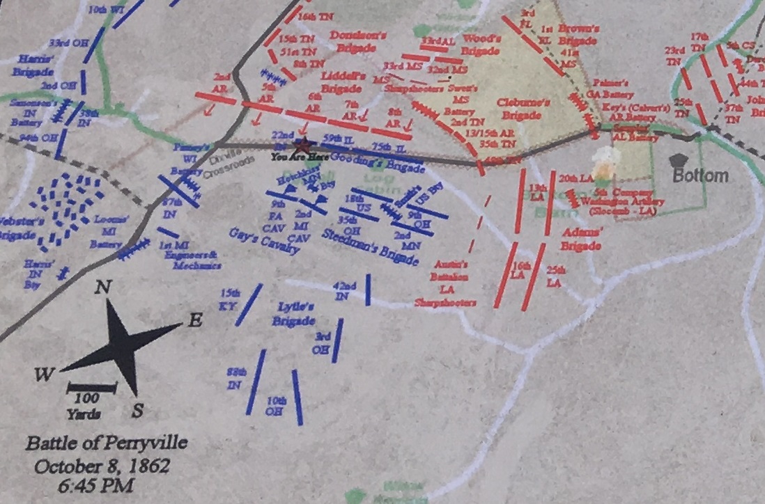
You'll see that the "You Are Here" marker puts us right in the thick of the 22nd Indiana Infantry's line. For all we know, we could have been within 100 yards of Lafayette's remains.
We then headed about 20 miles from Perryville to Harrodsburg where we visited the Shaker Village of Pleasant Hill. There are two Shaker Villages in Kentucky commemorating the remarkable lives of the members of a now mostly-defunct sect of Christianity called the Shakers. Per Wikipedia:
"The United Society of Believers in Christ's Second Appearing, more commonly known as the Shakers, is a millenarian nontrinitarian restorationist Christian sect founded around the year 1747 in England and then organized in the United States in the 1780s. They were initially known as "Shaking Quakers" because of their ecstatic behavior during worship services. Espousing egalitarian ideals, women took on spiritual leadership roles alongside men... The Shakers emigrated from England in the 1770s and settled in Revolutionary colonial America, with an initial settlement at Watervliet, New York (present-day Colonie). They practice a celibate and communal lifestyle, pacifism, uniform charismatic worship, and their model of equality of the sexes, which they institutionalized in their society in the 1780s. They are also known for their simple living, architecture, technological innovation, and furniture.
During the mid-19th century, an Era of Manifestations resulted in a period of dances, gift drawings, and gift songs inspired by spiritual revelations. At its peak in the mid-19th century, there were 4,000-6,000 Shaker believers living in 18 major communities and numerous smaller, often short-lived, communities. External and internal societal changes in the mid- and late-19th century resulted in the thinning of the Shaker community as members left or died with few converts to the faith to replace them. By 1920, there were only 12 Shaker communities remaining in the United States. At the present time, there is only one active Shaker village, Sabbathday Lake Shaker Village, which is located in Maine. Consequently, many of the other Shaker settlements are now museums."
There is a second Shaker Village in Kentucky called the South Union Shaker Village. That one was a little too far off our route, which is a shame since Elliott and I actually have an ancestor who was a Shaker at the South Union Shaker Village. Now how does that work, you ask, when as I bolded/underlined above, the Shakers practiced a celibate lifestyle? Well, like with all religions, some people get on board later in life. So my ancestor Roger Shackleford (1744-1825) fathered at least 8 known children (and almost certainly more) with his wives, of which he had at least two that we know of. Elliott and I descend from his second to last wife, Nancy Ann Carter, by their daughter Adeline, who later married Frederick Binkley. Adeline and Frederick are my 5th great grandparents.
Roger was still having children at least until 1811 when his son Hudson was born by his last wife, Sally Laird, but spent the last few years of his life until his death in 1825 living as a Shaker. The Shakers are renowned for their incredible artisanal skills and the architecture of the structures on their properties. They owned great swaths of land in Kentucky at one point, and the Shakers at Pleasant Hill owned a large amount of land along the Kentucky River. They constructed a path through the mountain between their village and the river so they could access the waterway, and today one can still take an old riverboat down the river for a tour--so that's what we did! We picked up our tickets at the main village and then headed to Shaker Landing for a ride down the river.

History of the Shaker Village
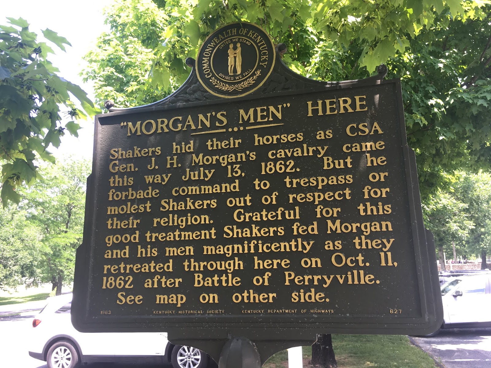
Some history between Morgan's Raid and the Shakers; I had several relatives among "Morgan's Men".

Interesting map showing the timeline of Morgan's Raid across Kentucky.

History of Shaker Landing

Enjoying a PB&J while we wait for our boat ride.

Some of the shared history between the Kentucky River and the Shakers.

Elliott is ready to board the Dixie Belle Riverboat!


All aboard!

Me and my best buddy.


Our next stop was our second Civil War battlefield of the day. Like the Battle of Perryville, the Battle of Richmond had a direct tie to our family's history. Some facts about the Battle of Richmond, per Battlefields.org [https://www.battlefields.org/learn/civil-war/battles/richmond]:
"In Maj. Gen. Kirby Smith’s 1862 Confederate offensive into Kentucky, Brig. Gen. Patrick R. Cleburne led the advance with Col. John S. Scott’s cavalry out in front. The Rebel cavalry, while moving north from Big Hill on the road to Richmond, Kentucky, encountered Union troopers on August 29th and began skirmishing. After noon, Union artillery and infantry joined the fray, forcing the Confederate cavalry to retreat to Big Hill. At that time, Brig. Gen. Mahlon D. Manson, who commanded Union forces in the area, ordered a brigade to march to Rogersville, toward the Rebels. Fighting for the day stopped after pursuing Union forces briefly skirmished with Cleburne’s men in late afternoon. That night, Manson informed his superior, Maj. Gen. William Nelson, of his situation, and Nelson ordered another brigade to be ready to march in support, when required. Kirby Smith ordered Cleburne to attack in the morning and promised to hurry reinforcements. Cleburne started early, marching north, passed through Kinston, dispersed Union skirmishers, and approached Manson’s battle line near Zion Church. As the day progressed additional troops joined both sides. Following an artillery duel, the battle began, and after a concerted Rebel attack on the Union right, the Yankees gave way. Retreating into Rogersville, the Yankees made another futile stand at their old bivouac. By now, Smith and Nelson had arrived and taken command of their respective armies. Nelson rallied some troops in the cemetery outside Richmond, but they were routed. Nelson and some men escaped but the Rebels captured approximately 4,000 Yankees. The way north was open."
Our family tie-in is that our uncle, on my mother's side, Gardner Holmes, was killed at the Battle of Richmond. He was the half-brother of my 3rd great grandmother, Phoeba Holmes, and the oldest son of my 4th great grandfather, Absalom Holmes. He was a 1st Lieutenant in the Arkansas 31st Infantry. He died during the second day of fighting, 30 Aug 1862, from wounds received in the fray. He and other the Confederates killed were unceremoniously buried in a mass grave in the city cemetery [Richmond Cemetery] under a small marker bearing the words "The Southern Dead".
Like at our previous battle site, we received some very helpful information from the guide at the Battle of Richmond Visitors Center. Since the battle occurred throughout the city, the markers commemorating it are spread up and down a long stretch of Highway 421. He was able to point out to me the places where the 31st Arkansas were engaged in fighting, where Gardner was likely taken after he was wounded, and where he was ultimately interred. The 31st are under the moniker Arkansas SS (Sharp Shooters) in the materials he gave me showing the order of battle, and they and four other units (all from Texas) were under the command of Col. McCray, who was the elected commander of the 31st. Regarding McCray, Wikipedia states: "He was elected major, then colonel, of the newly raised 31st Arkansas Infantry. He led a brigade of Texas and Arkansas infantry in the 1862 Kentucky Campaign. As part of Churchill's division, his brigade distinguishing itself at the August 30, 1862 Battle of Richmond, Kentucky. General Thomas J. Churchill singled out McCray for his "gallantry and coolness" in that action."
On August 30th, the bulk of the fighting in which the 31st was engaged--and most likely place that Gardner would have been wounded, was from 1:00-1:30 p.m. that afternoon when McCray's line engaged with Cruft's line of soldiers from Indiana, Kentucky, and Ohio. This was considered Phase II of the battle, and is seen referred to as The Battle of White's Farm as an engagement within the larger Battle of Richmond. We visited that spot, among others, as we explored the battle's landmarks.

Rendering of the Mt. Zion Hospital during the battle; it is likely this is where Gardner was brought after being wounded, and he probably died here.

Elliott in the Battle of Richmond Visitor Center.

Mt. Zion Church which became the battlefield hospital.


We started at the actual Battle of Richmond Park.
.


We eventually made our way to "Tour Stop 7" near the intersection of Duncannon Lane and Highway 421. Unfortunately, the visitors center guy told us that the surrounding property belongs to the U. S. military and they take issue with folks taking pictures in the area. He said that tourists have been accosted for it in the past, so I was only able to photograph these historical markers. But this was the area where the 31st engaged in their heaviest fighting and therefore is most likely where Gardner would have been wounded.


Finally we made our way to "Tour Stop 9", the Richmond Cemetery. A portion of the battle was fought here at the actual cemetery, and when the battle was over, the dead Confederate soldiers were buried here in a mass grave, including my uncle Gardner Holmes.

This memorial was erected by the Sons of the Confederacy a few years ago.


Finally, it was time to make our way east and begin what I considered to be the second leg of our Kentucky tour. Now we'd be heading to the "deep, dark hills of eastern Kentucky" [https://www.youtube.com/watch?v=cco-pCb0klU] from which my grandfather's people came. Our first stop would be in Beattyville in Lee County, where after setting up our tent, we went to visit our cousin Dorothy Barnett Couch. Her grandfather was Nathan Barnett, a half-brother (and cousin) of my grandfather's grandfather, Andrew Jackson Barnett. Nathan and Andy shared a mother, Phoeba Napier; their respective fathers, Jim and Jackson, were double-cousins, so in some ways they were genetically closer to full siblings than half siblings. They would probably share about as much DNA as 3/4 siblings (if you're unfamiliar with that phenomenon, 3/4 siblings are the products of one shared parent and their second parents are siblings to one another, meaning they still share the same set of four grandparents like full siblings do).
We previously met Dorothy's sister Phyllis during our trip to Indiana last year [http://thesaltofamerica.blogspot.com/2018/08/2018-genealogy-road-trip-part-one.html] and I have been a correspondent of their sister Judy for several years. My mother told me that when she met me, my great grandma Marie Barnett Marks proudly remarked that she had an uncle named Nathan, and I eventually figured out that she was referring to Nathan Barnett. Phyllis, Dorothy, and Judy are cousins to us in multiple ways because of the endogamy that was common in this part of the country [https://en.wikipedia.org/wiki/Endogamy], but the closest relationship would be Half 2nd Cousins Twice Removed to me, Three Times Removed to Elliott. I have corresponded with Dorothy several times the last couple of years and she wanted us to stop by and say hello when we were in town. She shared some great family stories she'd written several years ago that I was able to copy. She also had a photo of my uncle Nathan I had not seen and a photo of my 2nd great grandfather Andy I had never seen that was apparently from his funeral insert; I'm going to see if my grandpa has a better copy of it when I visit him next.


It goes on for several more pages; I love collecting oral history like this.

Photocopy of the funeral card for my 2nd great grandfather, Andrew Jackson Barnett.

Nathan and Rettie Barnett, my aunt and uncle.

Our campsite in Beattyville along the Kentucky River. We stayed at the Beattyville RV Park and Campground which had recently been update and was very quiet and clean.

Day 6 - Wednesday
After getting changed and grabbing breakfast, Elliott and I headed to one of the cemeteries I was most excited to visit: the Gabbard Cemetery, where my 4th great grandmother and an uncle lie. I spent a ton of time before we left on this trip getting precise GPS coordinates for as many of the cemeteries I wanted to visit as I could. Many were on Find A Grave, some were on other sites documenting cemeteries, and some I got from Stephen Bowling, the director of the Breathitt County Library. Since the majority of the cemeteries on my list were tiny rural cemeteries, most don't pop up in Google Maps or Google searches without extra digging. I also downloaded Google Maps' maps of Breathitt and Perry counties because I knew I would be outside the T-Mobile service area sometimes and would still need to find my way around while in deepest backwoods of the deepest back country that they warn you to avoid in basically every teen horror movie.
Originally, I had planned to visit 25 cemeteries, including two with unknown locations that I would be guided to by my cousin Judy. I knew I needed to whittle down that list so I had to cut a couple of cemeteries that I'll have to hope I can visit in the future. Later, Stephen Bowling was able to help me cut another off my list as well. I took three off three of the first four cemeteries I planned to visit, leaving only Gabbard. I originally planned to visit the graves of my uncles Patrick C. Napier (Roberts Cemetery in Lee County), William Napier (Kash-Brandenburg Cemetery in Lee County), and Levi Holland (Holland Cemetery in Breathitt County), but all three were quite a ways out of my way when taking into consideration that the rest of my route was strung together pretty neatly into a circle leading back to my campsites.
Additionally, when I started planning the trip there wasn't a picture of William's grave on Find A Grave, but then at the end of March, one was finally added, which decreased the urgency for me to visit there. I was also told the only stone for Levi was a recently-erected memorial placed by family members rather than his original stone. So as nice as it would have been to visit those three cemeteries, I decided that after Gabbard I would just head straight to Jackson. After about 20 minutes of driving out to the boonies--including a stretch that felt like it was straight up hill--we arrived at the Gabbard Cemetery.


Elliott with the Gabbard Cemetery sign.

The stone of my uncle Jessie Barnett. He is one of the three Barnett remaining siblings of my 2nd great grandfather Andy whose picture I have not yet found. The family story goes that Jessie was aware his death was approaching and so he made his own headstone. He was just shy of his 31st birthday (the same age I am now).

The stone of Rhoda Campbell Napier, my 4th great grandmother. Her homemade stone is an interesting one. It says she was a member of the "Babdis" [Baptist] church for years, and because it's clear the stone-carver was only semi-literate, many have assumed that is why the name "Rosan" Napier is on the stone. But I have reason to question whether Rosan was in fact her true name rather than Rhoda, but it is only a theory. She most often appears as "Rody" on Census and other records; on two birth records she appears as "Rhoda", and on one death record as "Rosa". The outlier is the 1870 Census which says "Susan". "Rosan" seems to me to be a lot closer to "Susan" than "Rhoda". It's all kind of weird and may just again be tied to poor literacy rates in this part of the country. But based on her residence in the 1900 Census being in close proximity to this cemetery and there being no other R-named Napier women born in the 1820s still living by 1902, we are confident this is in fact my ancestress, wife of Patrick P. Napier, whether or not her given name was in fact Rhoda or Rosan or something else entirely.

Elliott with the stone of his 5th great grandmother! Genetically, he may not have a drop of her Campbell DNA, but regardless she is still 1/128th of one of my three very favorite people of all time so I'm eternally grateful to her for the existence of myself, my boys, my father, siblings, grandfather, and scores of other awesome people.

Headstone for a mysterious Rosco Napier. He was infant that was born and died in 1897 and I have no idea who he is; he does not appear in any Ancestry family trees. I think he possibly could be a son of my uncle Patrick Carl Napier; he had children born in 1895 and 1898, so there is room for another in there, and that is who my grandmother Rhoda lived with. We also have another family tie to the unique name Rosco; Rhoda's grandson, the aforementioned Nathan Barnett (my uncle), named one of his sons Roscoe Barnett. So chances seem decent that this little guy was my 1st cousin several times removed.

This is another mystery stone for me that I would really like to figure out. It is nearly identical to Rhoda's stone; same size, same shape, and same handwriting. And it is in Rhoda's vicinity. I have wondered if since he made is own stone in 1907, if Jessie may have made his grandmother Rhoda's stone in 1902, and if so, then since I think the same person that made her stone made this one, Jessie may have made this stone. I cannot make it out, but I do see double-S's on the 2nd line. Rhoda's sister Evaline married a Gross, Jessie himself married a Gross, and there are several Grosses buried in Gabbard, so this person may belong to that family, but I can't be sure. I'm hoping to resolve this through an old cemetery transcription or other records if I can.
Once we finished there, we headed for Jackson. First thing when we came into town was the cemetery, so that was an easy stop. Unfortunately, the easiness stopped there because I was never able to locate where in the cemetery my aunt's grave is due to it never being fully surveyed. I was told "middle of the newer section" by Stephen Bowling and I knew what the stone looked like thanks to a Find A Grave picture, but after scouring the cemetery for over 20 minutes, it was time to cut my losses and get to my next stop. I was looking for the grave of my aunt Armine Barnett Combs, an elder half-sister of Andy Barnett. I at least still have the photo of her stone from Find A Grave, but it would have been nice to visit it in person.

Next stop, the Breathitt County Museum. Jackson's downtown seems like your standard downtown--had a little trouble finding a decent parking spot, but eventually managed it. We then spent a while studying the museum's exhibits.

Our families are several among this list, including Barnett, Boling, Campbell, Hay(s), Haddix, Hensley, and Holland.


Elliott loves fossils.


These pictures from area funerals struck me as particularly cool; since we would be visiting so many area cemeteries on this trip, it was cool to image similar scenes playing out for my relatives a their respective burial places.

The Breathitt County Library was nearby, so we didn't have to go far. Elliott got to play computer games and I got to go through the local genealogy collection looking for relevant information. I found several helpful books and ended up using my phone to copy 159 pages worth of information. Interestingly, most of the Breathitt information there was stuff I already had (from the Fort Wayne library) but I ended up getting a good deal of information for my Perry County families, so it all worked out.


We then headed over to the Nim Henson Geriatric Center where my aforementioned cousin Judy Barnett is a resident, as is another of her sisters. I was hoping Judy could use the maps and GPS I bought to guide us to a pair of cemeteries she'd visited many years ago, but she decided it would be easier to come along and guide us in person.
The two places we were looking for were the burial places of Jim Barnett and Angeline Barnett Banks. Jim was the first husband of my ancestress, Phoebe Napier. So he's kind of a step-grandfather sorts, but he is also my double-cousin. Jim's parents were David Barnett and Nancy Hays. My ancestor Jackson, who was Phoebe's second husband, was the son of Joshua Barnett and Jane Hays, who were siblings of Jim's parents, respectively, and so Jim and Jack were double-cousins. It is believed Jim died around 1890, and his cause of death is believed to have been feud-related, but any documented or precise information on when, where, or how he died has eluded us. Judy remembered happening upon the grave of a Jim Barnett who died around 1890 when visiting cemeteries with her father back in the 1980s, but wasn't sure if it was her great grandfather or not--they had come across it by accident.
The second grave that Judy had visited and I have failed to locate is that of my aunt Angeline Barnett Banks. A half-sister of Andy Barnett, she has been one of the last two of his 11 siblings whose final resting place I had been unable to pinpoint. Judy had told me previously that she had found and visited Angeline's grave, and she believed she could lead me to it.
We went looking for Jim's grave first, going south out of Jackson on Highway 30 and drove around quite a while. She remembered the cemetery was near a white church, and that the grave was along the cemetery fence. We made our way across Troublesome Creek at Clayhole and drove around for a while without seeing a white church or any landmarks that looked familiar to her. We had thought the Happy Church at Clayhole could be it as it was a white church, but there was no cemetery in the immediate vicinity. After driving down 476 awhile, we backtracked and I saw a marker on my GPS for a New Bethlehem Church. We hadn't seen it coming down 476 the first time, but I decided to look there since Judy was certain we were in the right area. Lo & behold, we came upon a little white building that I suppose used to be New Bethlehem Church, and it was next to a cemetery. Judy was pretty sure it was the right place.

Little Bethlehem Church in Clayhole, Kentucky
The church is next to the McIntosh Cemetery, which coincidentally was one of the cemeteries on my list I'd planned on visiting tomorrow. If I'd known this is where we were ending up, it would have saved us about an hour of driving around. But I don't blame Judy in the least; it had been decades since she visited here and she had no idea of the name of the cemetery. I immediately sought out and quickly found what I was looking for.

McIntosh Cemetery

This is the stone in question that Judy believed may have been her great grandfather Jim Barnett's stone. It says J. C. Barnett and has a date of 17 Mar 1890. The clue as to who this stone actually belongs to is on an adjacent stone.

The stone next to this is for Mary L. Barnett with a date of 20 May 1893. Judy believed this may have been another child of Jim and Phoebe we did not have documentation of. It turns out that this Mary was actually the wife of J. C. Barnett, and the dates on the stones were their dates of birth, not death. James Canoy Barnett was born 17 Mar 1890 and died 3 Nov 1970. His wife Mary, who he married in 1945, was born 20 Mar 1893 and died 29 Jul 1978. Their dates of death were never added to the stones. So unfortunately, these Barnetts are not my immediate relatives, and J. C. is not my cousin/step-grandfather, James Barnett.

Fortunately, the trek out here was still worth while because I was able to visit this grave, which I was already planning to visit the following day. Lizzie Barnett was Mary Elizabeth Barnett, daughter of Jackson Barnett, and half-sister of my 2nd great grandfather, Andy. She married her cousin, Milo Barnett, who predeceased her in 1914. She died in 1950.

Milo Barnett was Lizzie's first husband. He was the son of Thomas Barnett, son of David Barnett and Nancy Hays. So Lizzie and Milo were 2nd cousins, but more like "double 2nd cousins" since their fathers were double first cousins.

First wife of my cousin Estill Barnett, Mary Smith Barnett.

My cousin Evelyn Francis Barnett, daughter of Estill Barnett.

My cousin Estill Barnett, son of Lizzie and Milo, and his wife Mary Caudill Barnett.

My cousin Ova Lee Barnett, son of Estill Barnett.

Little Bethlehem Church

Inside the Little Bethlehem Church
The next few hours were rather trying. Judy was doing her best to remember where Angeline's grave was. She remembered it was up on a hill near a two-story white house that was well-kept with a large tree in the yard. We were looking for some particular landmarks to know where to turn, specifically a convenience store she stopped at with her sisters when she last visited Angeline's grave in the 90s. But as it turns out, Highway 1812 had been re-arranged in this area and a lot of landmarks were torn down to make way. We asked for help from multiple people in the area and they indicated there was a convenience store near the Napier "Park and Go" but it had indeed been torn down.
We eventually figured out it must have been on old Highway 1812; we had been going down and along the "new" 1812 looking for her landmarks. We were later directed on how to get onto the "Old" Highway 1812, but after driving up and down it twice, we still failed to find the house Judy remembered. Unfortunately, I needed to take her back to the geriatric center. It was a bummer to have to give up after about 3 hours of searching, but we didn't have a choice. It was still very nice getting to meet and visit with Judy. By this time, it had also been raining pretty heavily off and on throughout the afternoon which certainly did little to raise my spirits. But I decided I wasn't going to give up, and I went back up Highway 1812 to have another go. THIS time, I struck gold.
I went all the way up 1812 again and found nothing. On my way back toward Jackson, I saw a man and a child out in front of a house, so I stopped to ask him if he knew anything. He was from Perry County, but his wife was from this area. She came out and I explained everything that Judy had told me about the store and the white house. Judy had also said that after the store she had to cross two one-lane bridges before they got to the house. That detail struck this woman, Tiffany--whose surname and maiden name she mentioned but in my own stupid absentmindedness, I forgot to write down and have forgotten--and she led me down a stretch of Highway 540 off of 1812 where she said there were some of those one-lane bridges. If we took into account the store that was torn down to re-do 1812, then it was plausible that after heading down 1812 a ways (and across one one-land bridge coming up to 540) then going down 540 and across another bridge or two may have been what Judy was remembering.
We went down that way and found a promising house that met the description, but found no cemetery nearby. Tiffany stopped to talk to some folks she knew nearby and they reminded her of ANOTHER store that had burned down some years ago, one called the Neace Store. Once she remembered that, it all fit. The way Judy had described the store was that it was very close to the road and they pulled just barely off the road and were right up on the porch steps before continuing down the road that intersected Highway 1812. Apparently, the Neace Store burned down about 10 years ago, but it perfectly matched that description. So we backtracked to Highway 378; the store was apparently on the corner of old 1812 and 378. We went down 378 and went over another one-lane bridge.
At last, we came up on a really nice, white, two-story house with a large hill across the road. Judy had said Angeline was buried by herself up the hill from the nice house; her sister had said it was a small cemetery. We talked to the owner, and his last name happened to be Banks--Angeline's maiden name. It seemed like we were there! He even said there was a grave at the top of the ridge across the road...but that it was his son's grave. He said there were no other graves up that way. Angeline's husband was James Boston "Boss" Banks, and this man said Boss was his uncle and he knew him when he was young. (Boss didn't die until the mid-60s.) He said that Boss lived all up and down this road all the years this man had known him. He did not know Angeline, but she had died about 1944 from what my research indicated, which was when this man was a young child. He remembered when Boss died and thinks he was buried in the area, but did not think he would have a marked grave because he didn't ever have much money.
Disappointed, we continued down 378 hoping perhaps there would be another white house that matched the description. This road follows Frozen Creek and goes over it here and there; the area is called Sewell and we were headed in the direction of a locale called Taulbee. Further up the road toward Taulbee, we were told there was an old school house where a disaster claimed the lives of several children decades ago, and it is supposed to be a very haunted place. Tiffany was adamant that she would not go there but could lead us there if we wanted to check it out. I was still hopeful we might find Angeline's grave. Though we passed several small cemeteries, none matched the description from Judy and with my disappointment becoming increasingly palpable, I couldn't even muster the enthusiasm to stop and walk through them all, despite them all being rather small--some with as few as 15 graves, and some with as many as 40 or so.
After we'd gone down 378 far enough without a promising place to stop, we turned back around. We stopped at another house of a woman our guide knew who was about 100-200 yards down from the first house we'd stopped at, the white two-story. While our guide spoke to the home owner, I noticed there was a cemetery there. It did not have a sign with a name on it, and since we were just waiting around anyway, I thought "Why not?" And at last, fate smiled upon me--as soon as I walked into the tiny little fenced in plot (about 30 x 30 in size), I saw it: Angelina Banks, with a date of death in 1944. A misspelled first name, but next to her was none other than Boss Banks, and at the bottom of her stone was a little poem, which Judy had said would be there. I had finally found my aunt Angeline! I yelled down "She's here! She's here!", and Tiffany, who had come to take this quest of mine rather personally because she wanted so badly to help me, excitedly came up and we were enthralled to have found her at last. Between riding with Judy and then following my second guide, I'd spent the better part of five hours looking for this grave, and it was totally worth it!

Cemetery gate.

Inside the cemetery.


Stone of Angeline Barnett Banks [misspelled as Angelina], daughter of James Barnett and Phoebe Napier. Half sister of Andrew Jackson Barnett.


Headstone of James Boston "Boss" Banks.


Liza Barnett, wife of Robert B. Barnett.

Robert B. Barnett is an enigma. I have no idea who he is. His death certificate says his mother was "Sis Barnett". He is clearly a cousin of our Barnett family based on the 1940 Census showing him living with Marion Barnett, son of Thomas Barnett, son of David Barnett and Nancy Hays. The problem with him being Marion's cousin is that we do not know of any sisters that Thomas had; as far as we know, David and Nancy only had sons. So who "Sis" is and where Robert fits in the tree remains a mystery. No pre-1900 census records have been found for him to tie him to other relatives. So for now, he remains a mystery.

Cool but illegible stone near the Barnetts.

Poem on Angeline's stone.

Come to find out that this cemetery is referred to as the Flinchum Cemetery. Its GPS coordinates are 37.630062, -83.378269. Ironically, another Find A Graver also found and finally shared this cemetery to Find A Grave a mere four days before I did! That's totally fine; all I wanted to do was find my aunt. If only I had checked Find A Grave one last time in the morning before I left on my day's journey to find her and I would have found her MUCH more easily. But it was still a good adventure and great outcome. And I was pleased to see her stone and Boss's had been decorated; I don't know who has been coming to pay their respects to her, but I'm grateful to them for it.
We then had dinner at Pizza Hut in Jackson, basking in the ultimate success of our day's journey. Our camping site for the night was a little unorthodox. I could not find any formal campsites anywhere near Jackson; the closest ones were over 40 miles away. So I was pointed by Stephen Bowling to the Jackson Inn, whose owner might allow me to camp there. Graciously, he did so. We set up our tent near the pavilion next to the pond on the property. And although an obnoxiously loud toad apparently trying to mate and numerous trucks that bustled down the highway did their best to keep us awake, we slept fairly well for the most part.


I actually took these photos in the morning since it was already well past dark by the time we set up our tent.
Day 7 - Thursday
After breakfast, we headed to our first cemetery of the day: the Frazier-Taylor Cemetery. Just a few miles out of Jackson, it was up a steep hill behind a house and metal garage. There was a sign from the road indicating a cemetery was up the hill, but if you didn't know it was there already, it would be a tough one to find. Most of it was largely overgrown and wild; there is no sign identifying the cemetery. Only a small number of the graves have been mowed around and the rest make their way through the brush up the hill.


The only small plot in the cemetery that has been mowed around/kept up.

The rest of the cemetery looks like this; stones lost in the weeds.

I was there to visit the stones of my uncles Henry and William Barnett and hopefully find the stone of my aunt Mary Barnett Miller. All three are children of Joshua Barnett and Jane Hays. Henry died in 1919 and William in 1935 (after having married Henry's widow) and their grave photos are on Find A Grave. Those were clearly taken at a time when the cemetery was kept better. None of the ones I could see matched the pictures I had, but according to Stephen Bowling, the cemetery stretches over 100 yards back with stones scattered here and there throughout. With all the growth, I was risking a lot of ticks and snakes to find them, and that was not a gamble I was willing to take.
Mary's grave has not been photographed online yet. My hopes are that I will either return one day and the cemetery will have been trimmed up and allow me to find my people, or else someone local will eventually find and photograph the stone. Unfortunately, for now, this cemetery visit was a bust, as I was not able to find the stones of my Barnett kin.
Unfortunately, our bad luck was not going to end that quickly. We next headed to the Snowden Cemetery, where Joshua and Nancy Hays Barnett themselves are buried, along with a number of other Hays and Barnett kin. Snowden is the most strangely laid-out cemetery I have ever been to. Located behind a funeral home and up along (yet another) large hill, it is split by the road leading up the hill. It has plots on both sides of the road, most of which are completely overgrown. Based on some of the oldest legible headstones, it is one of the earliest still-surviving (but only just) cemeteries in the county, with stones dating to the 1840s. Stephen Bowling says this cemetery tops the area's annual list of "Most Endangered Cemeteries" every year.
Following instructions from Stephen on the phone, I tried to make my way to the "center" of the cemetery where the Barnett and Hays graves are, but couldn't find a clear enough path. There was a semi-cleared plot on the right side of the road (if you're going up the hill) but nearly everything to the left side--where I needed to be--was beyond overgrown. It was like the previous cemetery, but much worse--it's just a straight up forest now with headstones scattered among the trees.

The cemetery has portions on both sides of this road.

Some stones were visible among the brush, but most were completely engulfed.


This is at the beginning of the cemetery where there is a cleared area along the edge.
Near the start of the cemetery is the largest cleared section, an area starting where I photographed that last picture above. I could make my way around the the outer edge of the cemetery where there were more than a dozen Hays family graves, almost all of whom I recognize as cousins--mostly second cousins. Stephen wanted me to make my way back into the woods from there where it would be another 50 yards or so through the brush, but having already seen a snake in the area, I was not willing to risk injury for this.

Armine Hays

Infant of Garret Hays

Woodrow Wilson Hayes

John S. Hays

Garrett Hayes

Adrion Hays

Hays plot on edge of cemetery.

This is where Stephen advised me I should try to enter and it would be about 50 yards to the older Hays/Barnett plot.

This is what kept me from progressing any further.
Afterward, I went back to the library and got more information from Stephen. He was able to give me photos of most of the stones I was looking for because several years ago the Snowden Cemetery had been cleared away. He said it took about six weeks and cost over $8,000 for everything to be cleared away. After that was done, they were able to go in and photograph and document all the stones there. Unfortunately, after that initial clearing, no one kept it up and it has reverted back to the state it was in ten years ago. Stephen gave me permission to share the photos of the stones I didn't get to visit.

Headstone of Joshua Barnett [Jr.], my 4th great grandfather.

Headstone of John Hay(s). These Hays headstones are quandaries to me. My uncle Gabriel Hays states his father died in Mar 1839, and his mother Ursula is indeed widowed in the 1840 Census. But this says Apr 1840 and is with two other similar stones with women named Nancy, which makes me wonder if this is a different John Hays than my 5th great grandfather, father of Jane Hays Barnett, wife of Joshua. The proximity to Joshua's stone fits, but the incorrect month/year of death and its placement next to the two Nancy's has me wondering if this is the "other" John Hays that can be found in early Breathitt records.

Another view of the Joshua Barnett stone.

Another stone in the Hays/Barnett plot.

Mysterious Nancy Hays who does not appear in the 1850 Census.

Stone for Nancy Hays that appears to be a match with the John Hays stone, calling into question whether the John Hays buried here is indeed Joshua Barnett's father-in-law.
Stephen also gave me quite bit of interesting additional information. My aunt Nancy Barnett Miller, daughter of Joshua, is said to have been buried here at Snowden. But one day it was found her grave had flooded, and so the family removed her remains to the Watkins-Grigsby Cemetery about a half mile away. There is supposed to still be a stone for Nancy at Snowden, but her remains are supposed to be in an unmarked grave at Watkins-Grigsby. I was planning to visit Watkins-Grigsby, but with time constraints, it did not seem worthwhile to seek out an unmarked grave.
Stephen has a book coming out about Bad Tom Smith and his public hanging, and he gave me copies of some Barnett obituaries and death certificates, including the obituary for my uncle Gabriel Hays. It's a good thing we went over my list of cemeteries for the day, because he was able to keep me from going to one that would have been a silly use of time. I was planning to visit the Strong Family Cemetery where there is a military headstone for my uncle Zachariah Campbell. Stephen told me that stone was placed there a few years ago descendants or relatives and he is at a loss as to why.
Some extended relatives are there--including the wife and children of his nephew Joseph (son of John "Jarfly" Campbell"), but no close Campbell kin. It was believed Zachariah was buried in Tharp Cemetery where his father and other Campbells were, but his stone was lost...until a few years ago when Stephen found it beneath the ground's surface and brought it back up. So now I had no reason to visit the cenotaph/incorrectly placed stone at the Strong Family Cemetery, and I could just find the original stone at the Tharp Cemetery, where I was already planning to visit. Stephen's assistance in my research for Breathitt County has been absolutely invaluable and it is largely thanks to him that this latter portion of my trip was even possible, so I am permanently indebted to him.
After that, we headed for Ben Smith Cemetery. My 4th great grandfather, Patrick P. Napier, husband of the aforementioned Rhoda Campbell Napier and father of the Phoebe Napier, is buried here along with several other relatives. A number of Napiers I am either unfamiliar with or only vaguely familiar with are there as well.

Small chapel for the cemetery.


Large stone coffin memorial for Patrick P. Napier, my 4th great grandfather. He died 11 Nov 1870.


Elliott with the stone of his 5th great grandfather.

A cousin, Chad Napier.

One of several illegible stones in the immediate vicinity of Patrick Napier's stone. They are close enough to his memorial that they could be relatives, but I have no idea who they are. I feel strongly that one of them is likely his son Lewis Napier (1845-1903), though it was impossible for me to tell which (if any) was his.

Another illegible stone by Patrick's memorial. This one is the most legible; I can make out a name that starts with G (possibly Gladys), then I think it says Campbell and then Napier below that. I can also see an 1884. I can't find anyone like that in my or other family trees, so I may be mis-transcribing it. But I am at least confident about the Napier part, proving at least one of these stones in Patrick's immediate proximity was indeed another Napier.

A third one; you'll see its proximity to Patrick's, with the coffin in the right hand corner.

This one is next to Patrick. Any of these could be markers for some of Patrick's children, grandchildren, or even siblings (possible though unlikely as the last known residences for his unaccounted for siblings are not in Breathitt County). Who knows? There is a modern marker for his son Coleman Colbert "Colie" Napier in the 2nd part of this cemetery, but it is too new to be the original. One of these illegible stones could be the original. We also don't know where his daughter Emily Napier was buried, so she could be among these stones as well.

Another illegible stone.
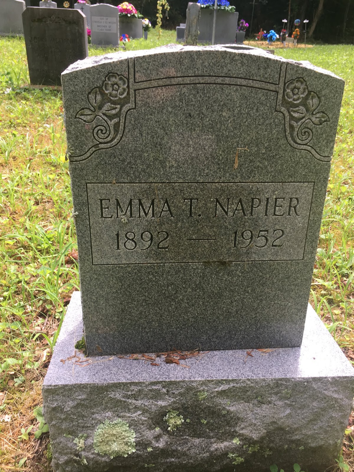


Like so many of these Breathitt cemeteries, Ben Smith is broken up into different places. There are four small cemeteries that combine to comprise the full Ben Smith cemetery. Patrick Napier is in the very first section, but we have additional relatives in the second section about 50 yards up a path from the first.

Anderson Whitaker was the son-in-law of Patrick Napier; he was the spouse of Leanna Napier.

Anderson was reputedly an ugly character. He stepped out on his wife Leanna and committed multiple crimes.

The stone of my aunt, Leanna Napier Whitaker. Her date of death is unknown; she was born in 1846. She died between 1880 and 1900.

As "Leanner"'s stone should be "Leanna", "Coley"'s stone should be Colby. Colby was the youngest known son of Anderson and Leanna. He was killed in 1895.
Richmond Climax, October 31, 1895, page 4.
Murder in Breathitt County.
JACKSON, Ky., Oct. 25 - Word comes from the south fork of Quicksand, in Breathitt county, that M. C. Bailey went out there to serve a writ on Anderson Whitaker. The latter's son, Colby, attempted to shoot the officer and was instantly killed by Frank Clemons, a deputy.

This shared stone was likely placed in the last couple of decades. It includes memorial information for my uncle Coleman Colbert "Collie" Napier, who died in 1897. He was a son of Patrick and Rhoda.

Sam Napier was the son of Coleman Napier.

Sarah Jane Russell Napier, Wife of Colie Napier.

Daughter of Sam Napier.

Remains of the stone of Arminta Craft Whitaker, wife of Patrick Whitaker, son of Leanna Napier.


Whitaker graves.

Shared Whitaker/Napier plot. There is also a Fugate and some Barnetts in this plot, but the Barnetts are unrelated to mine.

View of the first section on our return to the car.
I wanted to keep going through to the other sections of the cemetery, but unfortunately, we were being besieged by ticks. And not normal deer ticks mind you--Lone Star ticks. Their venom has caused over 1,000 people in the United States to become allergic to red meats. And I like my burgers and steaks too much to risk that nonsense. I pulled two off my arm and shirt and another off Elliott. Ended up finding another on my pants the next day and another on Elliott's head when he got a haircut the day after our return home; fortunately, the one on Elliott's head wasn't latched well and hadn't been there long, so he did not get sick. But they clearly latched onto our clothes and were waiting in our car to get a snack. As soon as I started seeing those ticks, I was done at Ben Smith and ready to move on to the next one. Maybe we can come back one winter and document more of it, because unfortunately it is not a very well-documented cemetery and there could be some more missing relatives I'm unaware of in there.
Our next stop was to the Tharp Cemetery. Tharp is the resting place of many of my Campbell relatives, including my 5th great grandparents--Rhoda Campbell Napier's parents--Lewis and Matilda Fugate Campbell. I also have at least one aunt and uncle each buried there, and likely at least one other--if not multiple others. Lewis's youngest son--by his second marriage--was William P. Campbell, who appears to have died about 1905. His sister Evaline died only about a year before and is buried here. Both lived near one another on George's Branch in 1900, so it follows that this is a strong candidate as a burial location for William--but no stone for him has been found. Other unaccounted for children of Lewis Campbell include Phoebe Jane who died after 1910, and Cole Campbell, who died in 1859, both in Breathitt County.


Headstone of my 5th great grandfather, Lewis Campbell.

Elliott with the stone of his 6th great grandfather, Lewis Campbell.

Stone for the wives of Lewis Campbell; we descend from his first wife, Matilda Fugate Campbell.


Headstone of our first cousin, Joseph Campbell, son of John "Jarfly" Campbell, son of Lewis.

Stone of my aunt, Evaline/Eveline/Evline Campbell Gross. Daughter of Lewis Campbell and his second wife, Poly (who may have been a Fugate or a Campbell).
Evaline's date of death is unclear. The 1880 Census gives her age as 7 in her father's household, making her born about 1873. Her marriage record in 1890 to Daniel Gross gives her age as "about 17", which also reflects this 1873 year. The 1900 Census gives her date and year of birth as Mar 1875. Her headstone says she died at age 31. Assuming that to be true, that would mean she died between 1904-1906. However, her husband Dan Cross remarried in 1902, indicating she was deceased by that time. It seems unlikely he would be remarrying due to divorce seeing as his marriage to Rachel Fugate occurred in the home of Evaline's brother William Campbell and her nephew John C. Campbell (son of Zachariah) is listed as a witness. Maintaining amicable ties with the Campbell family to me would not indicate he divorced their kin.
So it is more likely she died about 1901 (after the 1900 census and before Dan's 1902 remarriage. If she was actually 31, that would mean she was born closer to 1870. I think it is likely that like many of their Kentucky kin, they either did not properly track birth dates or if they did, they may have lost their family record. I think the 1880 Census and 1890 marriage are the best sources we should believe; she was likely born about 1873. That would make her about 28 in 1901, our approximate year of death for her, so her headstone is simply off. It is possible they were guessing on her age when she died, or the age or stone were added years after her death and they were again doing their best guesswork. As a result, we are also left to give our best guesses, but I am confident that she be listed as having been born circa 1873 and died circa 1901.

Headstone of Rosco Gross, son of Evaline Campbell. Here is that name Rosco again in this family, further indicating that the aforementioned Rosco Napier is our close cousin.

Headstone of Daniel Gross, husband of Evaline.

Headstone of Rachel Fugate Gross, second (or third if you believe their marriage record) wife of Daniel Gross. She is also my cousin through the Napier family; she was the daughter of Lewis Fugate and Elizabeth Napier. Elizabeth was the daughter of my uncle Patrick Napier and his wife Mahala Jackson; Patrick was the son of another Patrick Napier and his wife Fanny Brumfield.

Tharp Cemetery.


The re-discovered headstone of my uncle Dr. Zachariah "Zack" Gross, a Union veteran. Finding out this stone had been found here saved me a trip to the Strong Family Cemetery.

Zachariah's stone again.


Asbury Napier was the son of my aunt Emily Jane Napier, daughter of Patrick P. Napier and Rhoda Campbell. It is believed Asbury's father was none other than Anderson Whitaker, the husband of Emily's sister, Leanna Napier. Emily had at least five children by at least three and most likely four men; she did not marry any of them. Asbury's information on his siblings later in his life has helped in piecing this Napier family together.

Sarah Jane Bowling Napier, wife of Asbury.

Headstone for a Ralph Napier. Based on proximity and age, he was likely an infant son of Asbury.
We stopped for treats with our lunch at the food mart on Highway 15 near Haddix. Being that we descend from the Haddis family, that made it extra cool. And Elliott was super stoked on his miniature bottle of orange soda.

3.5 miles from the Tharp Cemetery is the Noble Cemetery, one of at least two cemeteries in this area that go by that name, at least according to Find A Grave; Stephen Bowling says, though, that Noble Cemetery #2 should be called the "Upper Noble" Cemetery--that one is located on Noble Rd. and will be our next stop. These small family burial grounds often changed names based on the families own the property over the years and the families utilizing these cemeteries most frequently.
Noble is where my uncle John "Jarfly" [or "Jar Fly"] Campbell is buried. Many people list him as "John Lewis 'Jarfly' Campbell", but there is no proof of a middle initial or middle name at all; it is complete conjecture at best. He died in 1896 and originally had a large crypt-like concrete covering on his grave. Sometime since, plunderers have taken the large slab concrete for themselves, so a new modern marker has been erected at the spot. Jarfly was the son of Lewis and brother of Rhoda. As mentioned, the burial locations of his siblings Phoebe and Cole are not accounted for. In my opinion, though I think Tharp is a decent candidate for their place of burial since Lewis and other siblings are there, I think the BEST candidate is this cemetery. Phoebe's husband George Washington "Wash" Noble is buried here; Jarfly was married to Wash's sister, Nancy. George was killed during the Civil War, and so died closer to Cole's year of death (1859), so Phoebe may be buried where her husband and at least one brother is.
Unfortunately, I neglected to photograph my uncle George Washington "Wash" Noble's stone. His death is a most unfortunate one; another of his brothers was nearly killed as well, and yet another was taken prisoner the night before and killed later. They were executed for disloyalty to the by Union soldiers, apparently for their disloyalty to the country, as Wash was a Confederate soldier, apparently on leave. The incident is recounted in a book by his nephew (who was named for him) of the same name--another George Washington Noble--Behold He Cometh In The Clouds (1912), pages 23-25:
[For context, Union soldiers were going around in mobs, harassing those they deemed disloyal, including members of the Noble family. George (the author) had been away from home, but had heard gunshots overnight. He returned to his parents the next morning, including his father, William, a brother of James, Lesson, and Washington. They must have been relieved to have their son home safely. This was 1863, so George the author would have been about 19 years old.]
"I got home for breakfast. My father and Mother met me at the front door and shook hands with me and wept with joy. That was the first timeI had ever shaken hands with them, and it affected me greatly.
... We had not been home long when an old slave by the name of Bailey came and told us that the Yankees waylaid the house of Uncle Washington, and when he came out had shot him right thru the body, and had shot at the old man. That was James Noble, his master. The old man had started up to see his brother, Washington, whom they had shot. His little boy had run down for the old man, and they were waylaying for him. They knew he would come that way. They were on a point at the mouth of the hollow where they were going to turn off to go to the river and as he come up opposite to them they began firing at him without saying a word to him. He was an old gray-bearded man, He turned around and looked at them and said, "Look at my gray hairs; you can't kill me, for God is with me." He said the Lord showed him that they could not hurt a hair on his head.
He said there about 15 in the crowd, and they just shouldered their guns and walked off, and he never moved until they got out of sight. About 12 o'clock Washington Noble died. The joy of my father and mother was turned into mourning quickly. They were afraid that they would come right on and kill us all, for it was his older brother whom they had shot, and now that his boys had come home out of the Rebel army, they would take revenge on them. It would be known who they were, for they had the night previous taken Lesson Noble, their brother, a prisoner. They took him off, and his son-in-law was there and knew them all. He was a Union man and they inquired of him about the country. He was out with them a good while, the family said. After that we could never hear anything about Lesson Noble. Richard Haddix, his son-in-law, said that he knew them all. It was Capt. William Strong with a company of men he was recruiting for the army.
...[George, his father, and other were hiding out from the Union soldiers in the days following, but he eventually returned home.] We stayed in the house that night, and I felt safe in my old home once more, although everything was looking very dangerous. Simpson and I went to see Uncle Washington buried. I got used to seeing dead and wounded man and it did not effect me much. I went back home and began to go about to see my neighbors, and got so I was not much afraid.
In November sometime, Jackston Field found out from some of the men where Lesson Noble was, and sent word to John Campbell [Note: This is Jarfly.]. Campbell went down to James Noble's and told him about it. They went over on John Little's creek; about two miles from his home, they found him. They had killed him and thrown him into a drain and put some chunks over him. The foxes had been eating him. They had kept him over on that branch as a prisoner until they came back, and when Capt. Strong came to the men and told them that they had killed Washington, they killed Lesson Noble, for they thought if they turn him loose he would go to the army and they would have him fight. The news went out that they had found him. I went and saw him before he was moved, and helped to move him to his house. The next day we buried him with his brother whom others had killed."
Karma would later strike down Captain Strong, as he was assassinated by his neighbors--many of them certainly family members of his victims--in 1897. This is Bloody Breathitt, after all, and that's how these things went in those days.

Steep incline leading to the Noble Cemetery.

Inside the Noble Cemetery; I did not find a sign.


Campbell family plot.

What remains of Jarfly's grave.

Jarfly's wife, Nancy.

Jarfly's son, Nathaniel.


For some nonsensical reasons, Google Maps had me take a winding route back a mile and down Watts Rd. to the Neace & Noble Cemetery. They are not very far and I could have just gone down Highway 15 a short ways. but I followed my GPS. The perils of technology, I guess. Neace & Noble is one of four cemeteries in close proximity along Neace Cemetery Rd. near Lost Creek. Here, I was looking for the stone of my aunt, Matilda Napier Fugate. Stephen told me this is where family records and educated guesses have led others to conclude she is buried. She died circa 1885, and was the daughter of Patrick and Rhoda Campbell Napier and the first wife of Benjamin F. Fugate, who died 35 years after her and is buried elsewhere.
Also said to be buried here is the intriguing Sarah Jane Johnson. She married first to Moses Clemons. She was widowed, and in 1890, remarried to none other than my 3rd great grandfather, Jackson Barnett. It is unclear to this day whether or not they formally divorced. I rather doubt it, as I have never found a legal marriage to Phoeba Napier. But Sarah did go on to legally marry to the aforementioned Benjamin F. Fugate, who had been left widowed by Phoeba's sister. They remained married until her death in 1919.
Unfortunately, I could not find either of their stones. Apparently, I was confused by my instructions to Stephen, and believed the "Upper Noble" Cemetery was the same as the Neace & Noble. As I said, there are four on this road and cemeteries had multiple names. But I went to Neace & Noble, looked for my aunt and step-3rd great grandmother, and of course did not find them. I realized later that I had simply gone to the wrong cemetery, which is a bummer. That will be at the top of my list on a return trip. So even though I found only distant cousins there, here are some pictures from our stop at the Neace & Noble Cemetery.


Despite our bad luck, I carried on to my next destination: the Grigsby-Smith Cemetery. This next stop also marked our crossing into Perry County from Breathitt County. It was fun getting to explore Breathitt and now we were looking forward to checking out our family's other primary Eastern Kentucky home: Perry County.
Of all the remote cemeteries I visited, this was definitely one of the two most remote. Most of the others were either right next to or down a hill from some residences, but this was in the middle of NOWHERE. Up a mountain (this one was not a hill) down a bunch of long, winding dirt roads, I eventually found it. Fortunately, my pre-downloaded maps of large chunks of Breathitt County REALLY came in handy for this one.

Entering the Grigsby-Smith Cemetery.


The stone we came to see: My aunt Eliza Jane Napier Grigsby, daughter of McCager Napier and Leanna Lewis.

Samuel was a Confederate soldier.

Not sure why a second marker for her was necessary when the original is still intact, but hey, here it is.


Love these coffin-shaped crypt-esque memorials. Very cool craftsmanship.
My original plan at this point was to head for the Eversole cabin, stopping at the Napier and Eversole cemeteries on the way. We would stay at the cabin tonight, explore Perry County further on Friday, stay at the cabin again on Friday night, and head home Saturday. But the day was still young; we were making much better time than I anticipated. We were also getting pretty fatigued from all our travel and not getting the most restful nights of sleep. So I made an executive decision to alter my plans. Though the Eversole cabin is in northeastern Perry County so geographically it made sense to head their next, I decided to forge on with what our plans were for tomorrow's stops, and then make my way back toward the cabin and family cemeteries that lie in that part of the county. So we headed for the Campbell Cemetery.
If we thought the Grigsby-Smith Cemetery was remote (it really felt that way because of the winding way we had to get there--we were really only about 100 yards from Highway 15, but couldn't access the cemetery from Highway 15) THIS one was definitely more so. The Campbell Cemetery was definitely the most remote grave yard we visited. We did pass a construction crew about 3-4 miles away, but other than that, we found very few signs of human life. We were visiting this cemetery to determine if it seemed like a good bet that this is where my uncle McCager Napier (1834-1912).
He is one of the 5 McCager Napiers on whom I have written extensively in the past (https://thesaltofamerica.blogspot.com/2012/05/sorting-out-5-mccager-napiers-of-perry.html). He is the only one whose final place of burial is still unclear. It is believed he is at the Campbell Cemetery. His son, John, is buried here, along with a number of his wife's family members, as she herself was a Campbell, and a cousin of mine, as her mother was an Eversole. I have conferred with some of the guys from the local Sons of Confederate Veterans group about getting a stone erected for my uncle McCager, but we were still trying to confirm if this seemed like the best place for it.


Infant child of John Napier.

Infant child of John Napier.

Infant child of John Napier.

John C. Napier, son of McCager.

Napier plot.

It's hard to tell from these pictures, but in person, there are clear person-sized sunken indentations in the soil immediately behind and beside the marked Napier graves.
Again, difficult to see in the pictures, but there are clearly at least 3-4 adult-size persons buried the marked Napier graves of John and his children, indicating to me that it is possible John's parents are among these 2-4 graves.


These last two pictures are of the indentations next to John Napier's grave. His wife is also a strong candidate for being one of these 3-4 unmarked graves.
It was my determination that there are unmarked adult graves in the Napier plot, and though that is far from definitive in showing McCager is there, I think it is the strongest candidate for his final resting place. I passed that information onto Faron Sparkman, who along with Manton Ray Cornett has corresponded with me regarding the McCager Napiers and various other relatives in the area for the last few years. Faron agrees with my conclusions, and the hope is that a marker can be erected at least for McCager, if not for his wife and John's wife as well. Even if McCager's remains are not buried here, as a marked grave for him has not been discovered elsewhere, there is certainly no hard in a cenotaph being created for him.
The plan had been, if we were still following Friday's agenda as-planned, to head south to Hazard and make our way back north through the eastern part of Perry County, but I decided instead to head south via the eastern part of the county toward Hazard and then go northwest toward the Eversole cabin. So this change in plans made our next stop the area of Hardburly and the Hardburly Baptist Church Cemetery where yet another Napier aunt is interred.

The cemetery stretches down the hill to the church.


Lewis and Mahala Napier Feltner. Mahala was another daughter of my 5th great grandparents, McCager and Leanna Lewis Napier.

Confederate stone for Lewis Feltner.


These Napiers couldn't make things easy on me and all be buried in the same place even though they're all buried in the same county. So our next stop was, of course, to see...another Napier aunt! I clearly no shortage of them. The Holliday Cemetery near Ary is the final resting place of Rachel Napier Holliday, the eldest known daughter of McCager and Leanna Lewis Napier.
There were many Napier graves in sight; Find A Grave lists over 30, but I managed to find several more that were not listed there and I photographed them while looking for my aunt. While I know all the Napiers in Perry County are my cousins to different degrees, it has been difficult for me to pinpoint my relationship to several of the Napiers I found here.


Inside the Holliday Cemetery.

Stone of a William Napier I have not identified. He was not on Find A Grave and I have not figured out what family he belongs to.

Another curious Napier. I do not know which family she belongs to and she was not on Find A Grave. There was a birth record for her naming her mother a Rachel Holliday, but I have found no record of any Rachel Holliday marrying a Napier, only my Rachel Napier marrying a Holliday--but she predeceased this child by nearly four decades.


Stone of Rachel Holliday Napier, my aunt who died in 1890.

Stone of Gilbert Holliday, husband of Rachel Napier.
So after visiting a number of their children, it was at last time to visit the graves of my 5th great grandparents, McCager and Leanna Lewis Napier. Again, I wish this family had made it easy on me by all being buried in the same place, but I think my hopes for that are about a century too late. Oh, well. At least I have been able to find most of the family. McCager and Leanna are buried at the Neace Cemetery near Bonnyman.
Their burial ground is on a kind of confusing stretch of cemeteries along Mt. Zion Rd. There are what's considered to be three different cemeteries in quick succession. The first is the Neace Cemetery where McCager and Leanna are; it is the smallest one. The next is the Campbell and Napier Cemetery, where their son Talton Jerome Napier is. These "two" are so close together that I'm not sure why they aren't considered one single cemetery, but apparently they're not. Just a little ways further is the Mt. Zion Church and its larger cemetery. This map shows where they are all located.

GPS Coordinates 37.335375, -83.212000. Red is the Neace Cemetery. Blue is the Campbell and Napier Cemetery. Yellow is the Mt. Zion Church Cemetery.
I came upon the crypt-style graves for McCager and Leanna shortly after turning down the road; I'd seen enough pictures of them to recognize them immediately, and I was thrilled to finally be visiting them in person.


Modern headstone of my 5th great grandmother, Leanna Lewis Napier.

Modern headstone of my 5th great grandfather, McCager Napier.


McCager and Leanna Lewis Napier graves.


Elliott with the stones of his 6th great grandparents, McCager and Leanna Lewis Napier.


Other small stones near the Napier crypts.

The "next" cemetery, known as the Campbell and Napier Cemetery.

Malinda Allen Napier, my aunt, wife of Talton Jerome Napier.

Military stone for my uncle Talton Jerome Napier, son of McCager and Leanna.

Original stone of Talton Jerome Napier.

A turtle in the cemetery that Elliott spotted.


Napier plot at the Campbell and Napier Cemetery.
Our next stop was to see--surprise, surprise--yet another daughter of McCager and Leanna; this time, it was their daughter Mary Ann "Polly" Napier Fugate. She is buried at the Fugate Cemetery. It is long-abandoned. It was restored to some extent several years ago, with the Noble Family Association adding several replacement stones for the interments there. But it is at the very top of a steep hill that I had no chance of driving up. The aforementioned Faron Sparkman and Manton Ray Cornett hooked me up with GPS coordinates to find it, and I did my best. But when I got as close as I could to the coordinates I was given, I simply could not find any of the graves. Everything was too overgrown.

This shows how close I could get to the cemetery given the rocky and overgrown terrain I was dealing with.


Though there was a rough road of sorts, this is all I could see as I looked in the direction of my GPS coordinates.
Though I was ultimately unable to find the stones, Faron very kindly sent me pictures of the stones that Manton Ray took when he went up to find the coordinates. They are great guys, those two.

Replacement stone for my aunt, Polly Napier Fugate.

Stone for Polly's son, Zachariah Fugate Jr.

Stone for Polly's husband, Zachariah Fugate Sr.
That was the last of our stops in this part of the county. We then drove into Hazard--which is a really nice town. Other than all the construction everywhere, I was very impressed with this bustling place. A nice little mall and beautiful library. I went through some materials at the library, but ultimately did not find anything I was looking for. I was specifically hoping for a few obituaries, but there were gaps in the paper for every date I wanted. So finally, I headed for the Eversole Cabin, with a couple of stops in that area along the way. The first of those was the Napier Cemetery, where in following with our theme of the afternoon we were visiting...yet another child of McCager and Leanna Napier. This time, it was their son Edmond Napier.

Sign from the road for the cemetery entrance.

Inside the Napier Cemetery.


My cousin Robert "Red Bob" Napier.

Lucinda, wife of Red Bob.

Obiga/Abiga Napier, daughter of William Napier, son of Edmond.

The stone of my uncle Edmond Napier and his wife, Polly Campbell Napier.
The Eversole Cemetery was our last cemetery of our trip. Though it contains my ancestors Jacob and Mary Eversole who originally built and lived in the Eversole Cabin, for some reason the cemetery is fair ways away from the cabin's location. I would have thought the family burial ground would be much closer than it is, but maybe that's just me.

The upper destination is the cemetery; the lower one marked with the red point is the cabin.
By road, it's a 5.5 mile drive. But hoofing it down the up or down the mountain--depending on your destination and point of origin--it's barely a half mile. We pulled up to the cemetery just as it started to rain a bit. Unfortunately, the cemetery had not been mowed recently, so it was pretty overgrown. Luckily, it's a very small cemetery, so I was able to find the graves I was looking for without much effort. But because of the rain and the overgrowth, I didn't get to photograph Elliott with his Eversole ancestors' stones.


Memorial stone for my 5th great grandmother, Mary Kessler Eversole.

Memorial stone for my 5th great grandfather, Jacob Eversole.

At last, we reached the pinnacle of this portion of our trip: the Eversole Cabin. Believed to have been built at least the 1820s and most likely earlier (some believe as early as the late 1700s but that seems to be pushing it), it was the home of the Eversole family for generations, starting with Jacob and Mary, and later their grandson, Major John C. Eversole. Due to this latter owner's (our 2nd cousin a few times removed) affiliation with the Union army, the cabin ended up being the site of a reported four minor skirmishes/engagements during the war. This branch of the family was also the one associated with an infamous feud in this area, the French-Eversole War. A small write-up I did on the War several years ago can be found here: https://thesaltofamerica.blogspot.com/2012/06/french-eversole-war.html
It is said the body of Ethan Sizemore, a casualty of one of the aforementioned four engagements at this site, is buried about 100 yards from the cabin in a lone grave. He was decapitated and his grave was found and reburied at one point in the 20th century. The current owners, Retired Judge Denny Noble and his son, Colby (whose home rests next to the cabin), aren't certain of the exact spot, but know the general area. Judge Noble, Colby, and a number of their friends and kin were gathered on the porch when we arrived, socializing and eventually telling us ghost stories about the cabin.
Denny's parents lived in the cabin up until the 1960s. Denny had fallen in love with the structure in his youth and worked to keep it up. He even hand-hewed the current roof shingles out of wood one by one. They have worked hard to maintain the structural and historical integrity of the building, despite not being Eversole descendants themselves. They took apart the cabin several years ago to repair foundation issues, but marked each individual slab of wood so they could put it back together exactly as it originally was. I was very touched that they have worked so hard to care for this old house, and proud that they were allowing me to explore it and even stay there overnight.

Elliott got to help feed the chickens, which he thoroughly enjoyed.

The Eversole Cabin


For years, neighbors have brought old farming implements and other antiques to the Nobles to put on display at the Eversole Cabin.


Back side of the Eversole cabin.


Inside one of the downstairs rooms, with the walls lined with antiques.


One of the upstairs rooms, both of which are primarily used for storage today.

On the eastern and western walls of both upstairs rooms, these holes were carved into the walls. They date back to the cabin's Civil War days, where the occupants could fire at their enemies outside. Dozens of bullets have been pulled from the walls of this cabin in the decades since.


The second upstairs room.


These roof shingles were individually hand-hewn by Judge Noble.


Colby's daughter cares for this abandoned calf they found a few weeks ago in a barn on Colby's brother's property across the road. Elliott enjoyed getting to feed and pet the calf.


Elliott also got to enjoy some little barn kittens.

View from Colby's brother's property down into the valley around the Eversole Cabin.


Elliott at the home of his 6th great grandparents, Jacob and Mary Eversole.


Elliott also got to enjoy the family trampoline.

It was dark by the time we were getting settled in for the night. We slept in what was the old living room when Colby's grandparents lived here. It was stifling hot in the room, so we would need to open both windows for a cross-breeze. But this being such an old house, there were no screens on the windows, so we would be inviting in every mosquito or other foul bug or creature that wanted to come inside. So ultimately, we decided to pitch our tent in the middle of the floor instead of putting our sleeping bags on the ground out in the open where we could be eaten.
The ghost stories the Nobles and their friends told didn't freak us out too much. We made PB&J's for dinner and watched Good Burger on the laptop. We didn't get any strange knocks or whispers or creaking floorboards during the night, which was nice.

This was one of our roommates though.

And her too.

But neither got up in the night to play the piano, so all was well.
Day 8 - Friday
We were up early the next day to head home. We had two stops on our way home. The first was the Loveland Castle in Loveland, Ohio. Per Wikipedia:
"Château Laroche, also known as the Loveland Castle, is a museum on the banks of the Little Miami River north of Loveland, Ohio, United States. A folly of a historical European castle, construction began in the 1920s by Boy Scout troop leader, World War I veteran, and medievalist Harry D. Andrews. He built the castle on promotional plots of land that were obtained by paying for one-year subscriptions to The Cincinnati Enquirer. Andrews named his castle after a military hospital in the Chateau La Roche in southwest France where he was stationed during the First World War. Its name means "Rock Castle" in French.
For over fifty years, Andrews worked on his castle project. He pulled stones from the nearby Little Miami River, and when that supply was exhausted, molded bricks with cement and quart milk cartons."
I thought this would be a fun place for Elliott to see, and I was right. We had an awesome time.


Elliott was pretty sure his brother Artie was in there.


We then headed to Columbus where we had a nice lunch with our friend Nicki and got to visit our favorite toy store: Big Fun!


We then went home where we surprised my wife and kids with our arriving a day early. This was an especially memorable trip for us and I hope we make our way back to Kentucky one day. Next year...Tennessee!